
Search
Remove Ads
Advertisement
Summary 
Loading AI-generated summary based on World History Encyclopedia articles ...
Search Results
Image
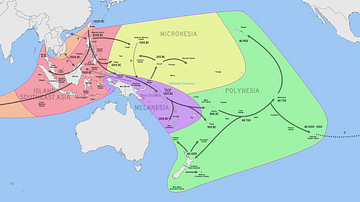
Dispersal of Austronesian People Across the Pacific
A map outlining the migratory paths of Austronesian speaking populations, including estimated dates.

Image
Austronesian Sail Types
Austronesian sail types: A: Double sprit (Sri Lanka) B: Common sprit (Philippines) C: Oceanic sprit (Tahiti) D: Oceanic sprit (Marquesas) E: Oceanic sprit (Philippines) F: Crane sprit (Marshall Islands) G: Rectangular boom lug...
Image
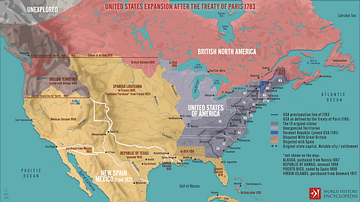
United States Expansion after the Treaty of Paris in 1783
A map illustrating the expansion of the United States of America following the Treaty of Paris (September 3, 1783), which ended the War of the American Revolution, recognized U.S. independence, and granted it sizeable additional territory...
Image
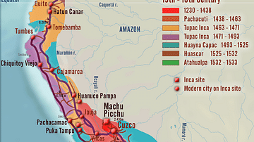
Inca Empire - Expansion and Roads
A map illustrating the various phases of expansion of the Inca Empire from its origins in the 13th century until the 16th century.

Interview
Interview: Shung Ye Museum of Formosan Aborigines
Indigenous peoples of Austronesian ancestry are the original inhabitants of Taiwan. Taiwanese indigenous peoples — formerly called Taiwanese aborigines, Formosan people, and Gaoshan (臺灣原住民族) — lived in relative isolation for over 5,000 years...

Image
Expansion of Early Islamic Caliphates
This map shows the expansion of the Islamic Caliphates in the 7th and 8th Centuries CE: 1. Dark Shade: Expansion under the Prophet Muhammad, 622-632 CE. 2. Medium Shade: Expansion under the Rashidun Caliphate, 632-661 CE. 3. Light Shade...

Image
The Phoenician Expansion c. 11th to 6th centuries BCE
A map illustrating the expansion of the Phoenicians, including the trade routes and process of Phoenician colonization, from its origins in the Levant region of the eastern Mediterranean, until its height when it spanned from Cyprus to the...

Image
Territorial Expansion of the Roman Republic (c. 260 - 30 BCE)
A map illustrating the expansion of the Roman Republic from its origins as a loose confederacy of allies and those called Latins in Italy (after the Latin War of 340 - 338 BCE) through more than 230 years of alliances, wars, and annexations...
Image
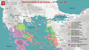
Greek Expansion in the Ancient Aegean
A map illustrating the trends and directions of the expansion of the ancient Geeks across the Aegean during the so-called Greek Dark Ages in the wake of the collapse of the Mycenaean civilization. During the 1100s BCE, fueled by a variety...

Image
Map of the Expansion of Macedon
A map showing the expansion of Macedon, around the time of the Peloponnesian War, between 431 - 336 BC.