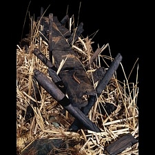
The Sweet Track is a Neolithic timber walkway, located in the Somerset Levels, England. It was originally part of a network of tracks built to provide a dry path across the marshy ground. The Sweet Track ran between what was then an island at Westhay to a ridge of high ground, close to the River Bruce. The remains of mounds have also been found at Westhay, indicating the remains of a settlement.
About 1.6 kilometres (1 mile) long, the Sweet Track was discovered in the 1970s CE during a peat excavation by Ray Sweet, (who also gave the track its name). Using dendrochronology (tree-ring dating) the track has been dated 3807/3806 BCE. For many years it was thought to be the oldest trackway in Northern Europe, until 2009 CE when a slightly older one was discovered in Plumstead, London.
The Somerset Levels are an area of wetlands and peats. The conditions of such areas can naturally lead to the preservation of organic materials. Materials become encased in a wet and airless environment, thus preventing, to a degree, decomposition. Wooden artefacts and structures have been recovered from the Levels, as well as the two well-preserved Iron Age villages of Glastonbury and Meare.
The track would have been built by a community of Neolithic farmers living in small settlements. Farming had spread from the Middle East and by this point was firmly established in Britain. According to pollen evidence, the whole of Britain would have been covered in forests at this time. The Neolithic peoples would have burnt and cleared the forests to have the land on which to grow their crops, mostly grains. A fair degree of organization is evident in the stockpiling of wood and construction of the tracks, and some members of the community would have had to have skills in woodworking. Using stone and flint axes, the trees for the track were cut on dry land with different cutting techniques used, depending on their age. Older oaks were cut vertically whilst younger trees tangentially. Modern research has been carried out using replica axes and the cut marks have also been studied to establish the methods of cutting used. The planks of wood were put together in the marsh, the final construction taking about a day to complete. Long poles were driven slantwise into the ground and then planks were laid in between, held in place by vertical pegs. The planks were made of oak, ash and lime. The poles and pegs were made mainly of hazel and alder. There are also remains of another track, known as the “Post Track”, which dates 30 years earlier than the Sweet Track, 3838 BCE. It ran roughly parallel to the Sweet Track, possibly used by the builders of the Sweet Track as an access route.
Artefacts have been found beside the track, among them, pottery and axe heads including one made of jadeite. Whether they had been deliberately buried, perhaps as an offering, or just lost, remains unknown. There have been many Prehistoric trackways found in England, but more than half reside in Somerset. Included in these are the Abbot's Way, Eclipse, Honeygore, Meare Health and Garvins tracks. They were constructed using varying styles, such as corduroy - laying short logs parallel to each other and side by side. The Sweet Track is the most well-known of these. It has been declared a scheduled monument (of national importance). Most of it remains in its original location and requires constant conservation to keep the wood in its damp condition. There are reproductions and a donated section now resides in the British Museum, London.


