The island of Gla, an enigmatic Mycenaean citadel in the north-eastern corner of the Copais basin lies 70 miles north of Athens, in the region of Boeotia. Lake Copais was the largest lake in Greece until the late-19th century CE when it was drained to create land for cultivation. As the waters receded, however, the unexpected remains of ancient ditches and embankments emerged. Traversing the width of the Copais basin, they provided tantalising evidence for an earlier drainage project, one dating to the last phase of the Greek Bronze Age around 1300 BCE. The discovery prompted archaeologists to re-appraise the mightiest but least known fortress of the Mycenaean civilization in Greece.
Bronze Age Boeotia
Boeotia today forms part of a long peninsula flanked by the Euboean and Corinthian Gulfs, terminated to the south-east by the region of Attica. Any maritime influence on climate, however, has long been mitigated by the mountain ranges surrounding the Boeotian plain. Fortunately, moisture evaporating from Lake Copais, in the days when it was still flooded, moderated the otherwise harsh continental-style winters and scorching summers.
Such would have been the climate during the Late Bronze Age. At that time the lake's shores were dotted with Mycenaean settlements, notably Orchomenos, a wealthy palace site in the north-west. There was also a string of Mycenaean forts in the north-east corner, centred on the citadel of Gla some six miles distant. This network of related sites suggests that Bronze Age Boeotia, as elsewhere in the Mycenaean world, supported a complex socio-economic structure under palace administration. Indeed much of mainland Greece was probably divided between several such powerful city-states – Mycenae and Tiryns in the Argolid, for example, and Pylos in Messenia – although the actual relationship between them is still hotly disputed, as is the mechanism by which power was transferred. Insofar as it can be trusted, Greek legend states that the Boeotian cities of Orchomenos and Thebes were enemies, and the forts around Gla were clearly built to protect the area from a neighbour or more distant invader.
Given Boeotia's tough local environment though and its concomitant limitation on resources, continued growth of a city-state could only have been sustained by increasingly specialised agricultural production. With this in mind, archaeologists have connected the Mycenaean draining of Lake Copais for high-yield agricultural purposes with the contemporary construction of the fortified citadel of Gla.
Lake Copais Drained
The Mycenaean city-states' most ambitious period of growth occurred between c. 1300 and c. 1250 BCE during the last phase of the Greek Bronze Age (known by archaeologists as Late Helladic III). It was at this time, for example, that the famous Lion Gate at Mycenae was erected. Whether this was a period of great confidence or great defensiveness, however, is again a moot point. The evidence suggests a combination of both for as the Arab scholar Ibn Khaldun wisely observed: "At the end of a dynasty there often appears some show of power that gives the impression that the senility of the dynasty has been made to disappear" (246). Sure enough by 1200 BCE many of the great Mycenaean palaces had been destroyed by fire.
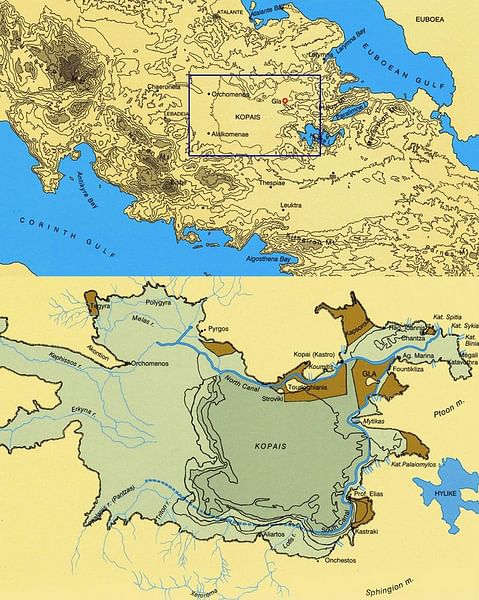
Prior to the cataclysm though, one of the greatest feats of Mycenaean engineering occurred. The draining of Lake Copais would be considered a huge hydraulic project today, never mind over 3,000 years ago. Was the project orchestrated by Orchomenos alone? Or did the city-states of Orchomenos and Thebes work on the project together despite their legendary enmity? Certainly a vast workforce would have been required to transform the roughly square-shaped lake, which at the time covered over 50,000 acres during winter, into the most fertile plain in mainland Greece.
Even during the Middle Helladic period (c. 2000-1650 BCE) attempts had been made to tame the lake to create cultivable zones known as polders. The largest of these polders was in the north-east corner of the lake in which stood the islet on which Gla would later be built. It was a rise in the lake's level following an increase in rainfall at the end of the Middle Helladic that prompted the idea to drain the lake completely (the mention of submerged Boeotian cities in Greek mythology may perhaps find their origins here, too).
So it was that Lake Copais, which was as much shallow marsh as clear water during the summer months, was artificially drained by means of a complex drainage control system. This involved diverting the course of six rivers that normally fed directly into the basin – notably the Cephissus, Melas and Hercyne – into two main west-east canals. The northern canal, for example, conveyed the floodwaters of the Cephissus and Melas from Orchomenos eastwards for over 15 miles. It was contained within massive earthen embankments and reinforced with masonry revetments, with pathways along the top that facilitated the transport of goods across the basin to the Kephalari Pass, and eventually the coast. Thus the water was diverted away from the basin eastwards into either natural limestone sinkholes known as catavothres (the concentration of forts in the north-east was clearly designed to maintain and protect protect these critical outlets) or else into the Bay of Larymna on the Gulf of Euboea. Some of the water was, of course, kept back to irrigate the polders created by the draining of the lake.
Archaeologists estimate that it took one or maybe two generations to excavate some 70 million cubic feet (c. 2 million m³) of earth to create the canals and embankments, the latter measuring over 6 feet (c. 1,8 m) high and up to 150 feet (45 m) wide. Additionally, over 8 million cubic feet (c. 225,000 m³) of stone was used to revet the embankments and there was possibly even a rock-cut drainage tunnel several miles in length referenced by the 1st-century CE geographer Strabo. The resulting outflow once the system was fully operational is estimated to have been in excess of 20,000 gallons (75,000 l) per second.
It is little wonder that such a grandiose project was not attempted again until the 19th century CE. By this time the lake had refilled naturally and was fringed with fertile land periodically encroached by floodwaters. To tackle this, between 1867 and 1887 CE French and Scottish engineers reclaimed the entire basin on behalf of the British Lake Copais Company. This time canals were dug to drain water from the lake into the River Cephissus from where it disgorged harmlessly into nearby Lake Yliki. The lake today been replaced with fields of swaying cotton and other crops.
Citadel of Gla
Around the same time the Mycenaeans drained Lake Copais, they also built the enigmatic island citadel of Gla. The structure's sheer size – its circuit wall encompasses an area seven times that of Mycenae – and the fact that its original name is unknown has long baffled archaeologists. 'Gla' seems only to have been coined relatively recently by Albanians living in the area, it being a corruption of their word 'goulas', meaning 'fortress' (likewise the modern Greek population calls the site Paliokastro, meaning 'ancient fortress').
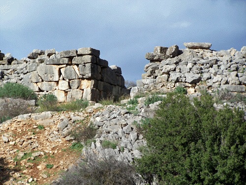
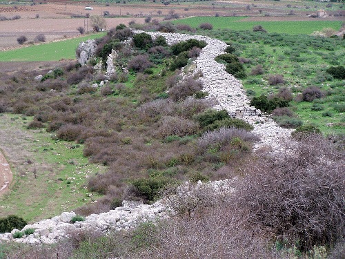
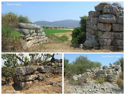
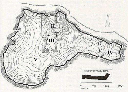
Best seen from the air, Gla occupies a triangular limestone plateau located just off the former east shore of the lake, rising up to 200 feet (60 m) above the surrounding plain. The citadel's most impressive feature is undoubtedly its walls, which encompass an area of around 55 acres (22 hectares). Overlooking the now dried-up lake bed, they run for almost two miles (c. 3 km) around the edge of the plateau. As with Mycenaean fortifications elsewhere, the walls are cyclopean, that is they are built from such large stones that the ancients thought them to have been the work of giants – the legendary Cyclopes. In reality, a large human workforce did the work, their work made slightly easier through quarrying the stones from the plateau itself and rolling them into place. The wall, which is uniformly around 19 feet (5,8 m) in thickness, is pierced by six gates, four main entrances made from dressed ashlar masonry reached by paved ramps, and two smaller 'sally ports' built of rubble.
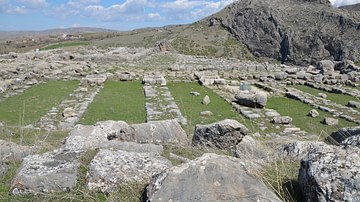
Whilst the circuit wall was always visible, the Mycenaean structures within had to be revealed through archaeology. The most impressive of them were excavated by French archaeologist André de Ridder (1893 CE), and the Greeks Ioannis Threpsiades (1955-1961 CE) and Spiridon Iakovidis (1981-1991 CE). They consist of a series of four walled enclosures, three of which in the central part of the citadel are built adjacent to each other and interconnected. One, the so-called Northern Enclosure, abuts the northern circuit wall and contains a large L-shaped complex set on an artificial terrace at the citadel's highest point. Its wings made of mudbricks on stone foundations comprise two-storey residential apartments connected by long corridors and staircases, terminated by spacious single-storey main chambers. The building debris contained fragments of decorative wall frescoes, evidence for a wastewater system, and, uniquely, clay roof tiles suggesting pitched roofs (Mycenaean artistic representations always show flat roofs). A road connected the Northern Enclosure with the citadel's Northern Gate.
A much smaller enclosure occupies the north-east corner of the Northern Enclosure but any structures it contained have been lost to erosion. Of greater interest today is the larger Southern Enclosure reached by means of an internal gate. This contains two long parallel ranges of small rooms, with long corridors and wide access ramps. North and south of the ranges are ancillary buildings. The Southern Enclosure is connected to the citadel's South Gate by means of another road.
The citadel's fourth enclosure stands alone at the eastern tip of the plateau, where it is formed by an internal wall built between the South-Eastern Gate and the northern circuit wall.
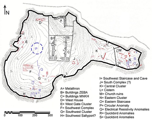
Subsequent excavations have revealed many more intriguing structures. During the 1980s CE, for example, the German archaeologist J. Knauss uncovered vestiges of a lower city on the plain west of the citadel, where it was protected from flooding by a dam. Back inside the citadel walls, a geophysical remote-sensing survey conducted in 2010-2011 CE by Greek archaeologists Antonia Stamos and Christofilis Maggidis demonstrated further widespread evidence for a variety of structures outside the four enclosures (some of these had already been revealed but not fully understood by the German archaeologist Ferdinand Noack back in 1893 CE as well as more recently by the British archaeologist and historian Richard Hope Simpson). While some of the buildings were initially revealed during the preliminary cleaning and surveying of the site, it was the remote sensing and topographic mapping that helped solidify the new picture of additional structures within the citadel. These included several long, well-built rectangular complexes with several large rooms, interspersed with clusters of less formal and more simply constructed buildings. Subsequent excavation of pottery, frescoes and figurines in 2018-2019 CE, conducted by Elena Kountouri, only served to confirm these structures as Late Helladic III in date.
Palace, Fort, City?
Despite this wealth of material evidence, an air of mystery still hangs over the island of Gla. For well over a century now archaeologists have wrangled over the purpose of the citadel and its place on Bronze Age Boeotia's socio-political map.
The early excavators suggested that Gla was the as-yet-unnamed palace of an as-yet-unnamed king. The well-built L-shaped complex in the Northern Enclosure certainly had the makings of a Late Bronze Age Mycenaean palace, with its lofty main chambers and high-status fixtures and fittings. The chambers, however, lacked the royal throne and central columned hearth that identify so-called megarons at palace sites elsewhere. Nor has any evidence for the bureaucratic archive of clay tablets associated with other palaces been found. Why might this be?
Perhaps the answer lies in the Southern Enclosure. The two long ranges accessed by ramps might be indicative of storerooms, especially as one of them contained a destruction layer of burned grain. Might it, therefore, be that Gla was not a palace but rather a fortified administration and storage centre from which the drainage works and agriculture processes (including redistribution and taxation) were orchestrated? It is quite feasible that once the drained plain had been turned over to crops it could have become the breadbasket for this part of Mycenaean Greece. If the project was indeed co-managed by Orchomenos and Thebes might this explain the twin-winged 'palace' and the twin storage ranges? This explanation would most likely remove the need to explain the unlikelihood of an unnamed palace being situated so closely to the well-documented palace of Orchomenos just a few miles away.
Through the 1990s CE, this theory attracted considerable support. The only amendment concerned the ranges in the Southern Enclosure, which were interpreted by some as barracks rather than storerooms, and their ancillary buildings as stables. Certainly, the citadel's location at the northern end of the Boeotian Plan became a strategic one once the lake had been drained. What no commentator could explain though was why the greater part of the citadel (outside the four enclosures) was seemingly void of structures. Why go to the enormous effort of building such a long circuit wall only to occupy little more than a quarter of the space within it? If the ranges were indeed barracks, might the unoccupied areas of the citadel have been reserved for farmers and their flocks, and other refugees from the lower city in times of unrest?
Back in the late-19th century CE, the predominantly empty citadel was perhaps less of a mystery considering the approach of archaeological pioneers such as Heinrich Schliemann, who homed in on palaces and tombs rather than the flimsier, less exciting domestic arrangements of the people. By the late 20th century CE, however, archaeology had become a science, with practitioners bringing modern technology to bear on sites once declared void of interest.
In this respect, the geophysical and mapping surveys conducted at Gla by Antonia Stamos proved a crucial turning point in the quest to explain the citadel's purpose. Almost overnight the area outside the four enclosures was brought to life with evidence for what appeared to be residential complexes large and small, workshops and storage silos. Taken in conjunction with the lower city down on the plain, the citadel suddenly looked less like just a fortified administration centre and more like the fully-blown capital of a Mycenaean city-state. This internal restructuring brings into question the role Gla may have played within the Mycenaean landscape. But what was its name? And why did it not appear in Homer's Iliad among other Mycenaean city-states providing ships to fight at Troy?
One long-held theory is that Gla is Homer's "Polystaphylon Arne" (Arne rich in vines). Unless Arne is definitively identified, however, this is impossible to prove. One factor against the designation would be the close proximity of Gla to Orchomenos not to mention the fact that vines prefer well-drained slopes to flat damp ground. Another possibility alluded to by the Greek geographer Pausanius is that Gla was the stronghold of the legendary Boeotian King Athamas, a likely contemporary of King Cadmus of Thebes. Again no hard evidence exists.
All these vagaries have recently led Christofilis Maggidis to propose a radical new identification for Gla. Might the citadel actually be Orchomenos? Of course, that city has long been documented on the north-west shore of the Copais Basin, where its legendary founders, the Minyans, built a frescoed palace and a great tholos tomb to rival the Treasury of Atreus at Mycenae. The Minyans are usually cited as having orchestrated the draining of Lake Copais with or without the support of neighbouring Thebes. But is it just possible that Orchomenos morphed at some stage into a site for ancestor worship whilst its burgeoning population relocated to the new citadel at Gla? This would certainly go some way to explaining the curious enclosure walls, which would have been deployed to demarcate palatial/administrative structures, storage areas and barracks from the civic area, as they still do in some towns today, and perhaps even to protect them from civic disorder (the present author would add that the missing bureaucratic archive might possibly once have occupied the small north-eastern enclosure lost subsequently to erosion). It is certainly a tantalising theory and one that deserves serious consideration.
Whatever the truth, the three major Boeotian centres – Orchomenos, Thebes, and Gla – were all destroyed by fire around 1200 BCE. Greek mythology attributes this regional destruction to either internal fighting between Orchomenos and Thebes or external aggression by Mycenaeans from the Argolid. Alternatively, the cities and drainage works might have been wrecked by an earthquake. Orchomenos and Thebes were later reoccupied albeit on a much smaller scale, but Gla was fully abandoned. Inevitably the Copais drainage works were abandoned, too, and in time the plain reflooded naturally obscuring the secrets of Gla for the next 3,000 years.
This article could not have been written and illustrated without the support of Christofilis Maggidis, Associate Professor of Archaeology, Dickinson College, Carlisle, PA and President of the Mycenaean Foundation, and Antonia Stamos, Associate Professor of Art History at the American University of Kuwait, Salmiya, Kuwait and Geophysics Lab technician for the Institute for Aegean Prehistory Study Center for East Crete (INSTAP SCEC). The results of their survey work at Gla can be found at http://glas-excavations.org/
