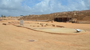
Caesarea Maritima, the city Herod the Great (r. 37-4 BCE) built for Rome on the southeastern coast of the Mediterranean served as the Roman Empire's powerbase of operations both commercially and militarily. With Rome's ultimate goal of adding Mesopotamia to its list of conquered territories, Caesarea would initially play an important role for Rome in the Near East.

The Parthian Factor
During the period when Caesarea Maritima and Herod's harbor were built, the extent of the Roman Empire included Europe, Anatolia, Northwest Africa, Syria, Phoenicia, and Egypt, but Rome's expansionist efforts did not stop there. Looking to expand beyond the immediate eastern Mediterranean areas, there was, however, Parthia: Rome's ablest competitor. A superpower in its own right, Parthia ruled a vast empire from 247 BCE to 224 CE. With control over an expanse of land ranging between the Mediterranean Sea in the west to India in the east, the most productive portion of its empire, key to its wealth and power, was the lucrative northern east/west Silk Road through Mesopotamia. Thus, any desire of Rome for expansion in the east would be molded and affected by Parthia's presence.
After Crassus (b. 115 BCE) had been defeated at the Battle of Carrhae, 53 BCE, and Mark Antony's Parthian campaign had failed in 36 BCE, a peace agreement was reached with Parthia, in 20 BCE. However, with the long-term strategy of still winning Mesopotamia, as Rome concentrated on solidifying control of the eastern Mediterranean region, Parthia's presence and jurisdiction of the silk routes through Mesopotamia was counterbalanced by the eastern trade network of ancient Rome via land routes through Arabia and sea routes by way of the Red Sea – and it would be Caesarea, with its strategic location, that would serve as Rome's base of power in the East.
A Base of Commerce
With superior tactics and long-term strategies, several elements contributed to Rome's expansionist success. In Roman warfare, troops and war machines were moved over an advanced network of roads, the Roman army employed professional soldiers, and the Roman legionary used standard equipment. However, perhaps as important to their imperial success was the offer of rank, wealth, and urban development for those they wanted to win over. As Mary Beard points out,
The foundation of towns from scratch, on a Roman model, was the most significant impact of Roman conquest on the provincial landscape. In other words, pre-existing hierarchies were transformed into hierarchies that served Rome as the power of local leaders was harnessed to the needs of the imperial ruler.
(492-93)
One of those leaders, Rome's main principal in the East, was Herod the Great, king of Judah from 37 to 4 BCE. His relationship with Rome was undoubtedly collaborative. With anticipation of great rewards, Rome gave much to Herod in return.
After becoming governor of Galilee in 47 BCE, Herod's relationship with the Roman government started with Mark Antony, who gave Herod a fleet of warships for his support against Augustus (r. 27 BCE to 14 CE). However, according to the ancient historian Flavian Josephus (36-100 CE), when Augustus defeated Mark Antony at the Battle of Actium in 31 BCE, Herod traveled to meet Augustus to curry favor. Not only did Augustus grant Herod, among other cities, the important trade center of Gaza (south of Caesarea) and allowed him to keep ownership of his bitumen trade at the Dead Sea, Herod also regained control of the Jericho plantations and the territories Cleopatra VII (r. 51-30 BCE) had filched. (Wars, 1.20.1-4)
Furthermore, along with these important sources of income, an arrangement was made between Augustus and Herod in which Herod was given "half the revenue of the copper mines in Cyprus, and committed the care of the other half to him, and honored him with other gifts and incomes" (Josephus, Antiquities, 16.4.5). This was no small acquisition since Cyprus was known for its prodigious copper production and was the place where copper got its name. Thus, as Herod claimed to be the recipient of "great riches and large revenues" with additional poll tax, property tax, sales tax, and duties on customs, he would parlay such income into his prodigious building program. (Antiquities, 15.11.1)
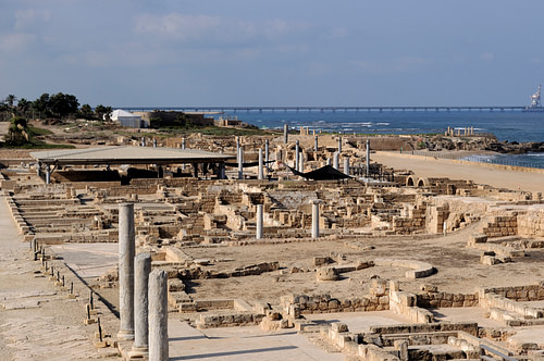
With 33 projects happening from 35 to 10 BCE, Herod the Great's building program included major infrastructure work at Jerusalem, Herodium, Samaria, Jericho, and the desert fortresses of Judea, but perhaps his most extensive project, and the one benefiting Rome the most, was Caesarea. Herod built the city from the ground up, complete with a temple, palaces, amphitheater, theatre, paved streets, and waterworks. The infrastructure of Caesarea Maritima included a modern-like sewer system, a 10.5 km (6.5-mile) aqueduct, four wide streets running north and south (cardines), and twelve narrower decumani that ran east and west. Of the cardines, setting the tone for Caesarea's splendor was the main thoroughfare, the Cardo Maximus. 16.5 meters (54 ft) wide and almost 1.6 km (1 mi) long, it was bordered with mosaics and impressively lined with 700 columns of the ornate Corinthian type.
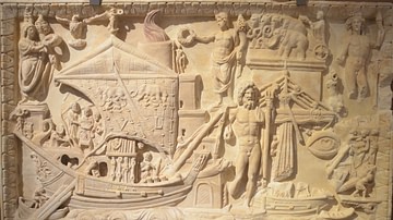
In their desire to enlarge their commercial network in the Near East, yet limited to the southern east/west trade routes, as Rome sought to control the Egyptian and African markets and the all-important trade routes through Arabia and the Red Sea, Caesarea was located with an advantage. Set on the eastern Mediterranean coast between Alexandria to the south and the Phoenician port cities of Tyre and Sidon to the north, the strategic placement of Caesarea with respect to commercial traffic reveals a purposeful design to capture income. With eastern products traveling west and ships moving north along the coast, Caesarea was well placed to make it a gateway to the west. Products from India and Indonesia would have moved west, then northwest via the Arabian and Red Seas. Merchandise from Egypt and Africa would have traveled north up the eastern seaboard for dispersal, then west throughout the Mediterranean. Similarly, as Caesarea's harbor was convenient for emptied or loaded ships transiting the Mediterranean and for loaded vessels moving north from Alexandria, Caesarea also traded with Gaza, which received goods from Africa, Arabia, India, and Indonesia, the most profitable which would have been pepper and frankincense.

Additionally, as Caesarea's trade network began to materialize when Roman emperor Trajan (r. 98-117 CE) finally controlled Petra in 106 CE; Rome now not only captured Gaza's markets but also controlled the flow of eastern goods from Petra en route to Gaza as well. As Gary Young points out, "incense was carried from Petra by road to Gaza" (92, 97). Thus, with Caesarea strategically located and Rome's possession of Petra - and Gaza with its diverse markets - it was now able to control not only Mediterranean commerce and eastern trade but overland trade to consumer cities like Bostra, Samaria, and Jerusalem. Finally, as Rome's largest income flow came from trade through the city of Caesarea, its harbor would have generated additional funds from docking fees, along with import and export tariffs.
Protecting Interests
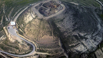
Even as it expanded its commercial interests, Rome was still in a constant state of war and found it necessary to fortify sites and cities. Besides Caesarea, examples would include the fortress of Antonia at Jerusalem and the fortification work at the desert fortresses of Judea. Built by the Jewish Hasmonean rulers from Jerusalem, these sites were tall hills (tells) that protected the vital north/south corridor leading to Jerusalem through the Jericho Plain and Judean Desert. After the Romans defeated the Hasmoneans and destroyed their mesa fortresses, Herod returned to them to rebuild and fortify. With a summit of 4500 square meters, at Machaerus, Herod rebuilt the fortress. At Cypros, which rises 250 meters (820 ft) above the Jericho Plain, with the ancient road to Jerusalem passing under its foot, Herod doubled the size of the summit to 2000 square meters and built an elaborate stronghold. At Masada, as it sits alone west of the Dead Sea and rises 434 meters (1424 ft) above the sea – along with mansions, a palace, an apartment complex and administrative center, and several storage buildings, Herod erected a fortified wall system with 27 towers that, with its 1290-meter (4232 ft) length, encircled almost all of the mount.
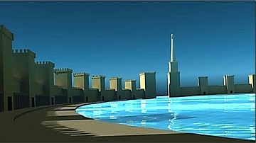
Regarding Caesarea, while the city lay within a fortified wall system enclosing 164 acres, its harbor, with an open entrance to the sea and key to Caesarea as a center of commercial activity, demanded special measures. Josephus mentions "very large towers" there (Wars, 1.21.6). Essentially built like a fortress at sea, using a combination of hydraulic concrete and huge stone blocks, some weighing up to 50 tons, the breakwaters, as they extended from shore, were laid out on a circular course enclosing 40 acres of water. Based on Herod's fortification work at Jerusalem, plausible dimensions at Caesarea's harbor include a curtain wall system approximately 5.5 meters (18 ft) thick and over 9 meters (30 ft) high. Based on the bow performance of the day, each curtain wall segment would have stretched approximately 30 meters between towers that were between 18 meters to 22 meters (60 to 72 ft) high and up to 11 meters (36 ft) square.

Additionally, like any fortification, where the entrance is most vulnerable, towers at the entrance to the harbor had to have been definitively outsized, likely reaching widths of 18 or more meters (60 or more ft), with dizzying heights reaching over 27.5 meters (90 ft). On top of these structures would have been battlements from which archers would shoot. Additionally, where the breakwater arms touched the shore, the same wall system continued on land – north and south of the harbor, parallel with the shore - to join the city's walls, completing an encirclement of protection for the whole city/harbor complex.
A Military Base
With the building and fortification of the city and harbor complete, though Herod built his own palace, the length of his stay at Caesarea is unknown. Nevertheless, Rome quickly took direct control once Herod died in 4 CE. As Barbara Burrell et al. point out, in 6 CE, Herod's palace "became the official residence of the Roman governor, and his kingdom became a Roman province, with Caesarea as its main port and administrative capital" (56).
Military action came when the Great Jewish Revolt of 66 CE was crushed with thousands of Jewish lives lost by Roman soldiers garrisoned at Caesarea, after which Vespasian elevated the city to the status of a Roman colony. Then when the Bar-Kochba Revolt (132-135 CE) ended with the destruction of Jerusalem, the provincial governor of Judea was raised to senatorial rank, and it was then, when Judea's name was changed to Syria-Palaestina, that Caesarea became the official capital of the Roman province.
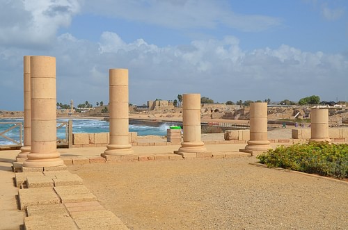
Additional evidence of Rome's military presence comes from the excavation of a Roman building at Caesarea dated to the 3rd century CE and called the Honorific Portico. The site yielded short columns bearing inscriptions honoring military notables on which presumably stood statues bearing their likenesses. Further excavation also revealed the building accessed a Mithraeum below. The Romans had converted one of Herod's underground storage vaults into a space for the practice of the mystery cult rites of Mithraism, which was popular among Roman troops. Furthermore, Rome's long-term presence at Caesarea is evident with a recent find at Herod's palace of "two column shaped pedestals with inscriptions honoring four Roman procurators that date from the 2nd century to the early 4th century CE" (Burrell, 57).
Drawing military, civil, and commercial connections, Robert Bull also adds:
After the Romans made Caesarea the seat of provincial administration. Roman procurators, residing in Caesarea, were charged with collecting taxes, overseeing civil affairs and recruiting personnel from the local population to serve as auxiliary legionaries. The troops were paid in bronze coins struck from a mint at Caesarea licensed by Rome. The coins were also used as a means of exchange in the area's rapidly developing economy.
(27)
Part of that developing economy, with Caesarea as a conduit of trade, would come with Trajan's military and commercial expansion in the Red Sea: "In the complex network of regions, it is the Red Sea that served as a funnel for goods from the East to the Roman Empire" (Tomber, 57). Roman interest in Petra, Gaza, and the Red Sea trade would be more fully realized with Trajan's annexation of the Kingdom of Nabatea as Provincia Arabia. The Nabateans were major traders and middlemen for goods coming from the east through Arabia and the Red Sea by way of their port, Leuce. It would be this lucrative market that Rome wanted a part of.
Besides evidence of the Nabatean presence in the Roman harbor town of Puteoli in 2003, on a Farasan island at the southern end of the Red Sea, 60 km (37 mi) from the Arabian coast, archaeologists found an inscription of dedication to the emperor Antoninus Pius (r. 138-161 CE). On it is mentioned the Legio II Traiana Fortis, a legion Trajan created. In keeping with the Roman practice of protecting commercial interests with military presence, it is likely the Roman presence at the strategic Farasan archipelago was a detachment of the main legion in Egypt.
Trajan initiated a period of Roman expansion in the Red Sea that had important commercial consequences. His successors also consistently pursued this policy, probably reaching its peak under Marcus Aurelius; it provided the right context for Roman commercial expansion in the East.
(Nappo, 71)
As Herod and Rome laid the groundwork for such expansion with the establishment of Caesarea in a strategic location in relation to trade with places like Africa since it had early jurisdiction over Gaza, which received goods from Petra en route from Arabia, certainly suggests Caesarea was a continuing player and conduit for east/west trade as well.

Moreover, reflecting urban growth fed by commercial expansion, as Caesarea's water supply was initially fed by a 10 km (6.5 mi) long aqueduct tapping into the Shumi Springs at the foot of the Carmel mountain range northwest of the city, another aqueduct, built by Hadrian (r. 117-138 CE), was added with an additional source of water 16 km (10 mi) east of the city. Then, a third low-level aqueduct was found to have its source in the Nahal Taninim River, 7 km (4.5 mi) north of the city. As Robert Bull points out, "This aqueduct, dated by pottery taken from beneath its concrete foundation, was in use in the fifth century. The volume of water carried in each of the aqueducts has been calculated and indicates that in the fifth century, the water demand of the growing city was about five times as much as it had been in the second century" (30). Such urban growth over a period of time suggests ongoing commercial expansion from an established network of trade in which Caesarea was the hub – the network and city that Rome was sure to protect.
Conclusion
While Rome's ultimate goal was to make Mesopotamia another Roman territory it was the Parthians that stood fast against Rome's imperial pursuit. Their initial defeat of Rome's incursion into Mesopotamia made Rome circumvent Parthia's presence. As a result, Parthia kept control of the lucrative northern east/west silk routes in Mesopotamia, while Rome would capture established trade routes in the eastern Mediterranean and make the lucrative southern east/west silk routes its own as well. While Herod's relationship with Rome was collaborative, as Rome gave Herod great sources of income, his building program, in turn, assisted Rome's pursuit in the east with the fortification of existing sites and the building of new ones. However, Herod's most important build would be the city of Caesarea with its strategic location in relation to eastern Mediterranean trade.
As Caesarea was built to become a hub of trade, Rome would protect it and its other interests with a military presence. Finally, after Rome had more solidly established itself in the east by Trajan's time, that it retained its goal of making Mesopotamia a Roman province is evident when, after the peace treaty with Parthia in 20 BCE, Rome would wage war on Parthia during Trajan's reign in 115 CE, and again under Lucius Verus (r. 161-169 CE) around 165 CE. Though both ventures ultimately failed, Septimius Severus (r. 193-211 CE) finally accomplished the task, though establishing a smaller portion of Mesopotamia as a Roman province. Ultimately, as Judea became a Roman province in 6 CE, as did western Arabia, as Arabia-Petraea, in 136 CE, and then Mesopotamia in 198 CE, it was Caesarea serving as Rome's powerbase in the East that facilitated Rome's expansive efforts in the early centuries of the first millennium.

