Tel Kabri is an archaeological site in northwestern Israel that is best known as the location of one of the largest palaces in Canaan in the Middle Bronze Age or "MB" (ca. 2,000–1,500 BCE). Although Tel Kabri reached the height of its power in the MB, it was inhabited during various periods both before and after the MB, from the Pottery Neolithic period (c. 6,400–4,500 BCE) through the Israeli War of Independence in 1948 CE. The site has been excavated by archaeologists several times beginning in 1956 CE, and since then, there have been three surveys, five minor expeditions and two major expeditions.
This article describes the archaeological excavations at the site. A summary of recent archaeological activities appears below, then a short history of Tel Kabri which summarizes the Kabri Definition, and there follows the detailed description of archaeological excavations at the site.
In the past few years, Tel Kabri has been in the spotlight for the discovery in the MB palace of wall and floor frescoes that are similar in style to those of far-off Bronze Age cultures in the Aegean (including those of Minoan Crete and the Cycladic Islands such as Thera). Kabri is one of only four Ancient Near Eastern sites where such frescoes have been found (the others being Alalakh and Qatna in Syria and Tel el-Dab'a in Egypt) (Cline et al. 2011, 256; Cline and Yasur-Landau 2013, 3–4; Wiener 2015).
Recently, in 2013 CE, in the western part of the palace, archaeologists discovered a previously unexcavated storage room and a corner of another. (See the Preliminary Report on the 2013 CE summer season, https://digkabri2015.files.wordpress.com/2013/09/preliminary-report-on-the-results-of-the-2013-excavation-season-at-tel-kabri.pdf.) There they found 40 tall ceramic wine jars that had been concealed in the earth for more than 3,500 years, making the Kabri storage area the oldest wine cellar in the world and the largest in the Ancient Near East (2013 Report, 4–6, 10; 2015 Report, 3–4).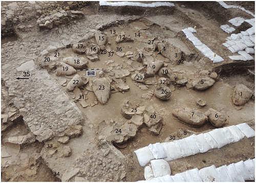
Perhaps most exciting of all, there may be many as yet undiscovered storage rooms. There are, for example, indications of additional rooms to the west of the Southern Storage Complex, of others beneath it, and of additional storage space under the modern road that runs alongside the Complex to its south. In future summer seasons in all these places, the earth may give up more jars—or perhaps other, wholly unimagined archaeological treasures… (2015 Report, 10–12).
A BRIEF HISTORY OF TEL KABRI
Although Kabri saw its heyday in the MB, the area was inhabited for thousands of years before the MB. From the Pottery Neolithic period (c. 6,400–4,500 BCE) Kabri was occupied continuously through the early part of the Chalcolithic period, or Copper Age (ca. 4,500-3,000 BCE) (Marder et al. 2002, 305). The inhabitants disappeared in the later part of the Copper Age, but then in the Early Bronze Age ("EB"), which began around 3500 BCE, a Canaanite town appeared and was occupied until the end of the EB in about 2100 BCE, when the town disappeared. Tel Kabri was unoccupied until early in the first part of the MB, known as "Middle Bronze Age I" or "MB I" (c. 2000–1720 BCE) when it was occupied again (Kempinski 1992, 127).
Throughout much of the second half of the MB, the site was dominated by the palace, which evolved through four stages, as follows (Yasur-Landau et al. 2014, 357–362):
The First Palace. Sometime in the middle to late MB I, Kabri's "first palace" and fortifications were constructed. The first palace, sometimes called the "proto-palace," probably resembled a fortress, and consisted mainly of two parallel stone walls—called the "corridor" by archaeologists—and a room to its north with a plaster floor.
The Second Palace. At about the time of the transition from MBI to Middle Bronze Age II or "MB II" (ca. 1720 BCE to 1550 or 1500 BCE), Kabri's palace grew larger and became the "second palace." The corridor and northern room of the first palace were filled in, and the second palace was created with the construction of three rooms to the east of the corridor area, and one or possibly two meeting halls to the west. A thick barrier of earth was built around the site, possibly as a defensive measure in the context of conflict with the coastal city of Acre and contention with Acre for control of the Western Galilee.
The Third Palace. Later on, in the MB II period, the palace was greatly expanded again—to the northeast and south, to create the "third palace." In the third palace, the emphasis shifted away from fortification to cultural matters and displays of wealth and power. The third palace incorporated advanced architectural elements, and was decorated with wall frescoes and floor paintings reflecting Aegean art styles and themes, perhaps representing an effort to suggest that Kabri was a player on the international stage (Cline et al. 2011, 256-257; Cline and Yasur-Landau 2013, 8; Wiener 2015).
The Fourth Palace. Later still, the palace expanded again and became the "fourth palace." The fourth palace included the Southern Storage Complex, and probably additional storage rooms to the north, and possibly to the west and beneath the roadway. The storage rooms that may lie beneath the Southern Complex probably belong to the third palace. The fourth palace was decorated in a more utilitarian way than the third, and the frescoes of the third palace appear to have been destroyed. Their fragments were used with the colorful painted sides turned face down as filler in plain floors and walls and possibly as temper in mudbricks (Cline et al. 2011, 249, 255).
Destruction of the Palace. In the late MBII, around 1550 BCE, or possibly earlier, the palace was destroyed, and the site was abandoned, for unknown reasons, but the storage rooms may contain evidence showing the reasons (Cline et al. 2011, 255; Yasur-Landau et al. 2014, 362–364).
After the destruction of the MB palace, the site was apparently unoccupied again until the 8th century BCE, during the Iron Age, when Phoenicians from Tyre established a town called Rehov and a garrison of Greek mercenaries at the site. However, in 585 BCE, the Neo-Babylonian armies of King Nebuchadnezzar destroyed the town and citadel of Kabri, and many other sites in the Levant (Kempinski and Niemeier 1994, 35*).
In 538 BCE, with the arrival in the region of the Persian armies of Cyrus the Great, a small village appeared on Tel Kabri which lasted until 332 BCE, in the time of Alexander the Great (Stern et al. 1993, 841).
In the Hellenistic period after 332 BCE, Tel Kabri itself was deserted and remained unoccupied until the Roman Period, when an area east of the tell took the name Kabrita and was occupied up to the foundation of the modern State of Israel (Lehmann 2002, 87).
In the Ottoman period (c. 1517–1917 CE), the Arab village of el-Qahweh (later called en-Nahr), and the later offshoot village of et-Tell, were occupied at Tel Kabri. This continued through the British Mandate Period (1920–1948 CE), which began after the World War I (in which the Ottomans were defeated), and during the Mandate period, a road was built that still runs through the tell. In the Israeli War of Independence, the inhabitants of the Arab villages at the site and of the village of Kabri to the east were forcibly removed, and in 1948 CE, the site became part of the current Kibbutz Kabri (Morris 2004, 253–254).
ARCHAEOLOGICAL EXCAVATIONS AT TEL KABRI
Early Excavations (1956-1976 CE)
In 1956 CE, kibbutzniks from Kibbutz Kabri began to find Neolithic artifacts at Tel Kabri on the northeast side of the site, and this led to an archaeological survey the same year. Then, from 1957–1958 CE, the first archaeological salvage excavation at Kabri was carried out by Moshe Prausnitz of Tel Aviv University and Robert Stiger of Brandeis University—in the area where the Neolithic artifacts had been found (Prausnitz 1959, 268–269).
In 1961 CE, installation of a pipe by the Israeli national water company, Mekorot, uncovered plaster floors at the site, the first evidence of Kabri's MB palace (Stern et al. 1993, 839). In 1969 CE agricultural work by kibbutzniks led to the discovery of MB tombs, which resulted in a salvage excavation the same year by Y. Ben-Yosef (Prausnitz and Kempinski 1977, 166).
In 1975 CE, Moshe Prausnitz returned to Kabri to continue the salvage excavations he had started in 1957 CE. Prausnitz was joined by Aharon Kempinski, then a young professor from Tel Aviv University (Stern et al. 1993, 839). In the course of the excavation, which covered three areas of the site and lasted from 1975 to 1976 CE, Kempinski fell in love with Tel Kabri and vowed to return to the site one day to excavate it fully (Kempinski 2002, 3).
Aharon Kempinski's Tel Kabri Expedition (1986-1993 CE)
Kempinski was as good as his word, and in 1986 CE, he began the first large-scale excavation of Tel Kabri. Kempinski's "Tel Kabri Expedition," which was joined by Wolf-Dietrich Niemeier in 1989 CE, covered many areas of the tell in its eight-season run. Kempinski and Niemeier managed to find many structures in the tell, including the MB palace structures, the earthen wall built with the second palace, and the Phoenician citadel (Niemeier 2002, 328–331).
The major focus of the Expedition was Kempinski's "Area D," which was the location of the MB palace structures and which, with several subdivisions, has been the focus of much of the archaeological activity ever since. There, in a part of Area D today called Area "D-West," Kempinski's team found the painted plaster fragments from a miniature wall fresco and the remains of a painted plaster floor. The painted floor was found in place in a large ceremonial hall, while the wall painting fragments had been moved from their original location. Based on stylistic comparisons, the artists or craftsmen who created the Kabri plaster paintings appear to have been influenced by similar styles and themes in paintings found in the Aegean region (Cline et al. 2011, 245, 249–254).
1993 CE was the final season of Kempinski's excavation. There were plans to return in 1994 CE, but Kempinski died a few days before the start of the 1994 CE dig season, bringing his Tel Kabri Expedition to an end. The final excavation report, Tel Kabri: The 1986–1993 Excavation Seasons was published eight years later in 2002 CE and was dedicated to Aharon Kempinski. Kempinski was buried at Tel Kabri, not far from the palace, in accordance with his wishes (Oren 2002, xv).
Rescue work after Kempinski (1999 CE and 2004 CE)
Following Kempinski's major excavation, there were two minor salvage excavations—one in 1999 CE led by Dina Shalem, and one in 2004 CE led by Howard Smithline. In the 1999 CE excavation, some architecture from the EB, and pottery from the Copper Age and MB II, were found (Shalem 2009, 19–39). The 2004 CE excavation was centered near the Iron Age citadel and provided some evidence that filled in the record of pottery for that period and the area (Smithline 2007).
The current Tel Kabri Archaeological Project (2005 CE–present)
In 2005 CE, Professors Assaf Yasur-Landau of the University of Haifa and Eric H. Cline of The George Washington University reopened excavations at Tel Kabri, after scientific surveys in 2003 CE found that the palace was larger than previously believed. After four seasons of exploratory excavations and surveys between 2005 and 2008 CE, large-scale excavation began in 2009 CE. The project has been ongoing ever since, with excavations in alternate summers.
The work is conducted through the Tel Kabri Archaeological Project, an expedition sponsored by a consortium consisting initially of the University of Haifa and The George Washington University, with Brandeis University joining in 2013 CE. Professors Yasur-Landau and Cline have been co-directors of the current expedition since the outset, and Professor Andrew Koh of Brandeis became Associate Director in 2013 CE.
A Study of Canaanite Society & Economy
The focus of the current expedition is the study of the Canaanite society and economy of Kabri and surrounding areas and their relationship to the wider Mediterranean world, particularly the Aegean, primarily in the palace period (Yasur-Landau et al. 2014, 355).
As part of this study, Kabri archaeologists have suggested that the construction of the first and second palaces, the fortification of the palaces and their outposts and the inclusion of a ceremonial hall as a meeting place in the second palace may be evidence of "social complexity" at Kabri (Yasur-Landau et al. 2014, 357–360). The term "complexity" is generally used of a society with centralized institutions that have sufficient authority to mobilize a large labor force to carry out massive construction projects like the palace, and whose leaders hold meetings with "decision-making groups" to organize their activities and need a meeting hall like those in the palace to do so (Yasur-Landau et al. 2014, 359). A comparison can be made with the Biblical site of Megiddo also in Israel, where the enormous and complex construction project required to build the "Great Temple" in the EB period is said to have provided evidence of "social-political complexity" (Adams et al. 2014, 301–302).
An incidental observation is the apparent absence of any representation of or reference to the Kabri rulers in any of the various artistic or cultural materials found in the palace (Cline et al. 2011, 256). The significance of this, if any, in explaining MB society at Kabri remains to be explored.
The current expedition's analysis of the Aegean-style wall and floor paintings in the palace is also part of the study of the relationship of Kabri with the wider Mediterranean world, including the influence of the Aegean area on the art, culture and society of Kabri.
The expedition's excavation work has been focused on Kempinski's "Area D," with a view to discovering more information about the MB palace structures. Area D has been greatly expanded as the current expedition's work has progressed, and it has been subdivided into Areas D-West, D-South and D-North, with further subdivisions from time to time.
Stratigraphy of Tel Kabri
The Tel Kabri archaeological site is located on a tell, which is a manmade mound consisting of layers or strata, each composed of the remains of a period of occupation, deposited one on top of the other. The most recent layers are on top., and as the layers continue downward, they represent earlier and earlier periods of occupation The layers at Kabri date from the Neolithic period (the deepest layers) to modern times (the layers nearest the surface).
The strata at Kabri are called "phases" by the current expedition. The identification and analysis of strata are called "stratigraphy," and our Table 1 summarizes the stratigraphy of Kabri.
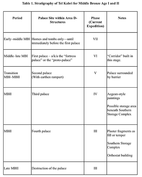
As with most archaeological sites, the strata or phases at Kabri are numbered, with Kempinski using Arabic numerals and the current expedition using Roman numerals. The sequence of numbers is based on two things. First, as we have said, the more recent layers are nearer the surface, and the older layers are naturally deepest. Second, when archaeologists dig, they start at the surface, encountering the newest layers first, and so strata numbering systems usually (but not always) start with one ("1" or "I") at the surface, and the numbers increase, layer by layer, as the archaeologists dig down into older and older strata.
It should be noted, however, that our Table 1 shows the oldest layers on top, with newer layers listed as we move down the table. This means that the stratum or "phase" numbers begin with the highest at the top (e.g., Phase VII), representing the oldest layers, and decrease as we move down the table to more recent layers (e.g., VII, VI, V, etc.). Table 1 links each stage of the palace's development to the stratum or phase in which remains of that stage have been found.
Thus, as shown in Table I, remains of the first, second, third and fourth palaces were found in Phases VI, V, IV and III, respectively. The material remains of structures and events related to each stage of the palace were found in the phase related to that stage. For example, as indicated under "Notes" in Table 1, remains of the "corridor," which was part of the first palace, were found in Phase VI. The Southern Storage Complex, related to the fourth palace, were found in Phase III, while the possible earlier storage area beneath the Southern Complex, which related to the third palace, are likely located in Phase IV. The plaster fragments of Aegean—style paintings were found in Phase III, where they were incorporated as fill or temper in the fourth palace, whereas, if they had remained in their original locations in the third palace, they might have been found in Phase IV.
Excavations By the Current Expedition
Picking up on Kempinski's discoveries, the current expedition has found additional plaster fragments, painted and unpainted, in Area D-West and also in Area "D-South," an area to which the third palace was extended. Some fragments apparently came from the same wall and floor paintings as those found by Kempinski, while others came from another painting which had a distinctive blue background, or from another painted plaster floor (Yasur-Landau et al. 2014, 360–361; Cline and Yasur-Landau 2013, 4).
Some of the painted fragments have been put together—as in a puzzle—to reconstruct some of the scenes painted on plaster. A comparison of these with ancient artistic works from Aegean cultures shows artistic and thematic similarities that strongly suggest that the Kabri paintings were created by artists from the Aegean, or by local artists who were influenced by them, either in the Aegean or at Kabri (Cline et al. 2011, 249–254; Cline and Yasur-Landau 2013, 2, 4; Wiener 2015).
Like Kempinski's wall painting fragments, many of those found by the current expedition had been moved from their original locations, and, as we have said, many of the painted fragments found by the current expedition were placed painted side down. This suggests that the fragments were used in the fourth palace not for their artistic qualities but as filler in plain surfaces, while other fragments may have been used as temper in mudbricks (Cline et al. 2011, 249, 255; Yasur-Landau et al. 2014, 362).
Discovery of Storage Areas - 2013 and 2015 CE
As discussed above, in the 2013 and 2015 CE seasons, Kabri's archaeologists discovered at least 110 ancient ceramic storage jars in the four-room Southern Storage Complex. Organic residue analysis of the residue in the jars from the 2013 CE season confirmed that all of the jars tested contained tartaric acid and other components of wine, and the results from that season alone showed that the Kabri storage area was the world's oldest wine cellar, and the largest known from the Ancient Near East. Residue analysis is being conducted on 80 residue samples from the 70 plus jars found in 2015 CE to determine what they may have contained—wine, or something else…. (Koh et al. 2014; Wilford 2013; 2015 Report, 1, 5, 13).
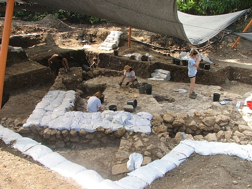
As mentioned above, the excavations through the 2015 CE season revealed the extent of the four-room Southern Complex, plus the storage areas to the north. Looking ahead to 2017 CE, it is possible that archaeologists will find additional storage areas in at least three places—to the west of the Southern Complex, under the roadway to its south, and even in the stratum beneath the Complex which contains the remains of a more ancient period. Burnt material discovered in a probe of the stratum beneath the Complex suggests that at least one storage room in that stratum was destroyed by fire (2015 Report, 1, 4–12, 14).
Analysis of the results for the 2015 CE season will include testing of samples of clay from the jars, and of soil, pollen and animal and plant matter clinging to the jars. In addition, the array of pottery types represented by the jars will add to the pottery typology for this period in this region (2015 Report, 13–14).
Organic samples from the storage rooms and jars may also allow more precise radiocarbon dating for the final two phases of the palace and possibly for its destruction, as well as data that may be helpful in the ongoing study of the chronology for the Eastern Mediterranean in the MB (Yasur-Landau et al. 2014, 364). According to the expedition's Preliminary Report for 2015 CE, the Southern Storage Complex and the jars showed evidence of violent destruction. Some of the walls were collapsed and some jars were shattered and found in positions indicating that they had fallen from shelves. Examination of this scene of destruction may help unlock the mysteries of the palace's final days (2015 Report 5–8, 13–14).


