
Search
Remove Ads
Advertisement
Search Results

Image
Map of the Dominant Religions in Europe, 16th Century - Shaping Nations Through Faith: The Religious Landscape of a Changing Continent
This map illustrates the major religious divisions across Europe during the 16th century, a period marked by the sweeping changes of the Reformation. As Protestant movements challenged the authority of the Catholic Church, the religious landscape...

Image
Map of the World in the 14th Century
The 14th century was a time of crisis and transformation across much of the world. Plague, war, shifting power structures, and intellectual ferment reshaped societies from Asia to Africa, Europe to the Americas. Despite profound instability...

Image
The Roman Empire and the Crisis of the Third Century, c. 270 CE - Pretenders, Breakaways, Plague, and the Fight for Unity
The Crisis of the Third Century (235–284 CE) began with the assassination of Emperor Severus Alexander (reign 222–235 CE) in 235 CE, triggering the collapse of centralized imperial authority. Over the next five decades, Roman power fractured...

Image
Map of the Silk Road During the Late 8th Century
In the late 8th century CE, the interconnected caravan routes later termed the “Silk Road” formed a transcontinental system linking East Asia, Central Asia, the Islamic world, and parts of Europe. The label “Silk Road” (German: Seidenstraße...
Image
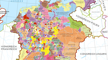
Holy Roman Empire in the 13th century CE
A map in German of central Europe during the time of the Hohenstaufen Emperors, primarily showing the territories of the Holy Roman Empire and the Kingdom of Sicily. The map is a vectorised version of this map from Professor G. Droysens...

Image
Map of the Trade in the Indian Ocean 15th-16th century - From Afro-Asian Exchange to European Intervention
The Indian Ocean trade network of the 15th and 16th centuries formed one of the most extensive and dynamic systems of exchange in the premodern world, linking East Africa, the Middle East, South Asia, and Southeast Asia. This maritime system...

Image
Map of the Migration Period in Europe in the 4th-5th Century
The Migration Period in Europe (c. 4th–6th centuries CE) marks a prolonged era of movement, conflict, and political transformation rather than a single moment of collapse. Following the death of Emperor Theodosius I (reign 379–395 CE) and...
Image
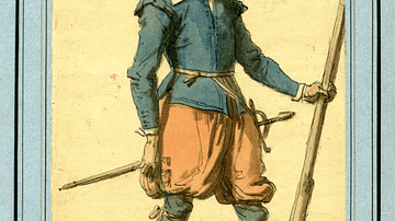
17th-Century Musketeer
A drawing of a typical 17th-century musketeer. Musketeers were a standard component of European infantry armies of the period and particularly during the English Civil Wars (1642-51). Ink and watercolours. Drawn in the 19th century. (British...

Image
Map of Japan in the 16th Century CE
A map of Japan during the Azuchi-Momoyama period (1568-1600 CE).
Image
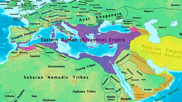
Byzantine & Persian Empires in the 7th Century
A map showing the extent of the Byzantine Empire and the Sasanian Empire in the 7th century.