
Search
Remove Ads
Advertisement
Search Results

Image
Roman Forum in the 5th Century BCE
A painting of the Roman Forum as it probably would have appeared in the 5th Century BCE. By Vilius Petrauskas.
Courtesy of Ancient History Magazine / Karwansaray Publishers.
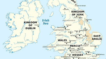
Image
British Isles at the Beginning of the 10th Century
British Isles in 10th century represented with the coastline at the time.

Image
16th century CE Desk with Lute, Globe and Books
A detail of a mid-16th century CE painting by Hans Holbein the Younger showing a desk with a lute, globe and books. From 'The Ambassadors', c. 1533 CE. (National Gallery, London)

Image
Detail of a 6th-century Elephant Mosaic
Detail of a 6th-century mosaic floor that used to decorate the pavement of the peristyle court of the Palatium Magnum, the Great Palace of Constantinople. The Great Palace Mosaic Museum houses mosaics from the Byzantine period, unearthed...
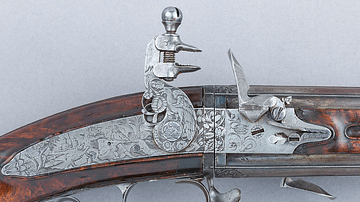
Image
17th-Century Flintlock Mechanism
An example of a 17th-century flintlock firearm mechanism. A piece of flint was held in the vice which the trigger pulled down to strike a metal bar which created a spark to ignite the priming powder which then set off the main charge of gunpowder...

Image
East Roman Empire, 6th century CE
East Roman Empire, 6th century CE, showing the territories of the Avars, Goths, Franks, Lombards, Saxons, Thuringians, Slavs.

Image
Janissary Uniform, Early 19th Century
Illustration of a Janissary's uniform, drawing by John Heaviside Clark, included in Thomas McLean's The Military Costume of Turkey. Illustrated by a Series of Engravings, from Drawings Made on the Spot, plate 5, 1818. This image of an early...

Image
18th-century Mughal Miniature Quran
A miniature Qur'an in vellum binding. Mughal Empire, 18th century. (Victoria and Albert Museum, London)
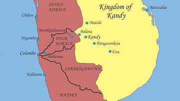
Image
Sri Lanka, Early 17th Century
Political situation in Sri Lanka, early 17th century.

Image
View of Edo Castle in the 17th Century
View of Edo on a pair of six-panel folding screens, 17th century.