
Search
Search Results

Image
Africa after The Treaty of Versailles, c.1920
A map illustrating the geopolitical situation in Africa after World War I - the continent still under European colonial domination, with only a few areas having gained independence or achieved limited autonomy. Although many African soldiers...
Image
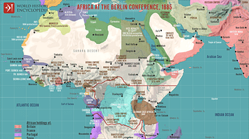
The Scramble for Africa after the Berlin Conference, 1885
The Berlin Conference of 1884-1885, also known as the Congo Conference, was convened by European powers to regulate colonization and trade in Africa during the New Imperialism period. Led by German Chancellor Otto von Bismarck at the request...

Image
Spanish Main & West Indies c.1720 - Spain, France, England, and the Dutch in a Struggle Over Trade, Treasure, and Empire
This map captures the shifting tides of colonial power in the 1700s, focusing on the strategic coastlines of the Caribbean Sea and the Gulf of Mexico. Once dominated by Spain, this region—known as the Spanish Main and the West Indies—became...
Image
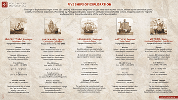
Five Ships of Exploration
This infographic illustrates five notable ships from the Age of Exploration, a period during the 15th and 16th centuries when European powers sought new trade routes, territories, and knowledge of the world. Several notable ships played key...
Image
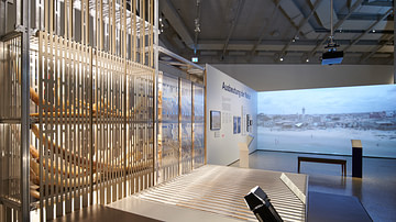
Swiss Colonial Entanglements Exhibition Space
View of the Swiss Global Entanglements exhibiton at the National Museum Zurich from 13.9.2024 - 19.1.2025.
Copyright: Swiss National Museum. Used with permission (Press release).

Image
Battle of Dogali
Oil on canvas painted by Michele Cammarano in 1887 showing the battle of Dogali near Massawa, Eritrea. The battle was fought between Italian troops and those of the Ethiopian Empire in January 1887. Despite the fact Italy lost the battle...
Image
Exhibition: Switzerland's Global Entangelments
View of the Swiss Global Entanglements exhibiton at the National Museum Zurich from 13.9.2024 - 19.1.2025.
Copyright: Swiss National Museum. Used with permission (Press release).

Image
The African Slave Trade, c. 1750
By 1750, Africa had emerged as the center of three major slave-trading systems: the transatlantic, trans-Saharan, and Indian Ocean trades. These interconnected networks linked African societies to European, Middle Eastern, and Asian markets...
Image
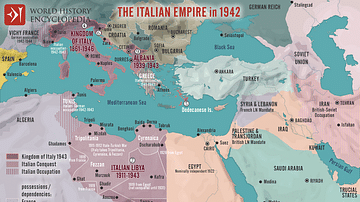
The Italian Empire in 1942
This map illustrates the extent of the Italian Colonial Empire, established during the era of New Imperialism as Italy sought to assert itself alongside the great powers of Europe. Driven by both economic ambitions and national pride, the...
Image
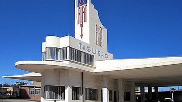
The Fiat Tagliero Building in Asmara
The Fiat Tagliero Building is a service station in Asmara, Eritrea. It was designed by the Italian engineer Giuseppe Pettazzi and completed in 1938. It is one of the most iconic buildings in Asmara