
Search
Remove Ads
Advertisement
Search Results

Article
Slavery in Colonial America
Slavery in Colonial America, defined as white English settlers enslaving Africans, began in 1640 in the Jamestown Colony of Virginia but had already been embraced as policy prior to that date with the enslavement and deportation of Native...
Image
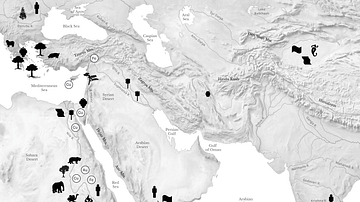
Resource Map of the Ancient Middle East
Map showing some of the major regional resouces of the eastern Mediterranean, the Near East, East Africa, and Central and South Asia.

Image
East Indiamen in a Gale
A c. 1759 painting by Charles Brooking East Indiamen in a Gale showing ships of the East India Company. (Royal Museums Greenwich)

Video
History of the English East India Company
Did you know the English East India Company’s tea trade was fueled by the opium trade? The English East India Company (EIC) – also known as the British East India Company – was an immensely successful trading company founded in 1600...

Image
East India Company Fort, Bombay
A c. 1665 illustration of the British East India Company's fort at Bombay (now Mumbai). (National Archives of the Netherlands, The Hague)

Image
Askari Troops, German East Africa
A photograph showing a parade of African Askari troops commanded by German officers in German East Africa. Taken some time during the First World War (1914-18).
German Federal Archives

Image
Dar es-Salaam, German East Africa
A photograph showing Dar es-Salaam when it was the capital of German East Africa. Taken some time just before or during the First World War (1914-18).
German Federal Archives

Definition
Audiencia
An audiencia began as a judicial institution in medieval Spain, but in the 16th century, it was applied as the highest form of local government in key cities of the Spanish Empire. An audiencia had a panel of judges made responsible for the...

Image
Dutch East India Company Trading Regions
Map of East India, taken from the Atlas van der Hagen, Koninklijke Bibliotheek, The Hague Part 4. This map of South East Asia was published by Nicolaas Visscher II (1649-1702). The map shows the entire trading region of the Dutch East India...

Image
Map of the East India Company Trade, c.1800
The English East India Company (EIC) was established by Royal Charter on 31 December 1600 under Queen Elizabeth I (reign 1558–1603), granting it a monopoly on English trade east of the Cape of Good Hope. Initially conceived as a commercial...