
Search
Search Results
Article
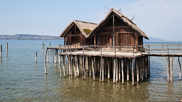
Prehistoric Alpine Stilt Houses
Alpine stilt houses are a unique and fascinating aspect of prehistoric architecture in the Alps, which provide valuable insights into the lives and culture of the ancient communities. The houses were built by prehistoric communities living...
Article
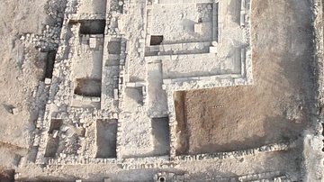
The Archaeological Excavations at Magdala
Magdala, known as Migdal in Hebrew (מִגְדָּל: tower) and also as Taricheae (Ταριχέα, from the Greek Τάριχος or tarichos: preserved by salting or drying fish), was an important fishing town during the first century CE on the western shore...
Article
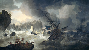
Top 5 'Deep-Dive' Virtual Shipwrecks
According to UNESCO, an estimated three million shipwrecks are scattered in the oceans’ deep canyons, trenches, and coral reefs and remain undiscovered. These shipwrecks preserve historical information and provide clues about how people lived...

Video
How Magellan Circumnavigated the Globe - Ewandro Magalhaes
View full lesson: http://ed.ted.com/lessons/how-magellan-circumnavigated-the-globe-ewandro-magalhaes On September 6, 1522, the "Victoria" sailed into harbor in southern Spain. The battered vessel and its 18 sailors were all that remained...

Image Gallery
A Gallery of Historical Maps
This gallery of 30 maps traces the history of cartography, with examples of maps made by cultures from the Paleolithic to the early modern period. The maps cover cities, states, continents, sometimes the entire world as it was known at the...

Image
European Colonization of North America c.1750
A map illustrating the systematic European colonization of North America during the Age of Exploration, spanning from the 1490s to the outbreak of the French and Indian War in the 1750s. It captures how Spanish, French, English, and Dutch...
Image
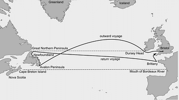
John Cabot's Route to Newfoundland
The Italian explorer John Cabot (aka Giovanni Caboto, c. 1450 - c. 1498 CE) sailed from England to eastern Canada in 1497 CE. His exact route and points of exploration are unclear and the map is therefore only an approximate guide.
Image
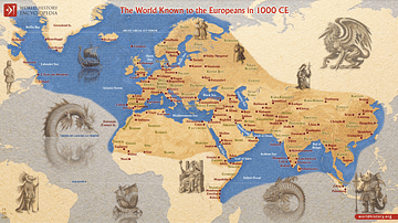
The World Known to Europeans in 1000 CE
In 1000 CE, Europeans had a limited but expanding awareness of the wider world, shaped by trade, exploration, and religious contacts. The Vikings had pushed westward, reaching Greenland and Vinland (North America). At the same time, merchants...
Image
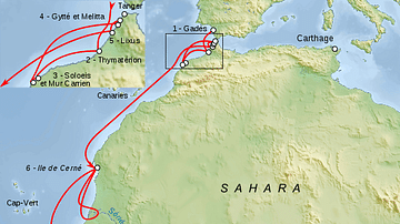
Voyage of Hanno the Carthaginian Explorer
A map indicating the possible route of Hanno, a Carthaginian who led a colonising and exploration expedition down the Atlantic coast of Africa in the 6th or 5th century BCE. Some scholars suggest he reached modern Sierra Leone, others that...
Image
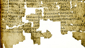
Aetia by Callimachus
A 2nd-century CE papyrus of Callimachus' Aetia.
B.P. Grenfell & A.S. Hunt, The Oxyrhynchus Papyri: Part XI. (London: The Egypt Exploration Society, 1915), plate IV