
Search
Search Results
Image
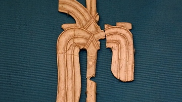
Carved Ivory from Samaria
This carved piece of ivory, in a Phoenician style, is part of large number of ivories which were found in the city of Samaria during the excavations of J. W. Crowfoot in 1931-1935 CE. They consist, for the most part, of furniture inlays...

Video
Columbus, de Gama, & Zheng He! 15th Century Mariners. Crash Course
In which John Green teaches you about the beginning of the so-called Age of Discovery. You've probably heard of Christopher Columbus, who "discovered" America in 1492, but what about Vasco da Gama? How about Zheng He? Columbus gets a bad...

Video
Expansion & Consequences: Crash Course European History #5
European exploration had a lot of side effects. When the Old World and the New World began to interact, people, wealth, food, animals, and disease began to flow in both directions. In the New World, countless millions were killed by smallpox...

Video
CHS Docent Cont. Education: The Portuguese Empire, AD 1415 to 1668
This video is brought to you by The Friends of Coronado Historic Site © https://www.kuaua.org/ Our Friends on Facebook: https://www.facebook.com/Friends-of-the-Coronado-Historic-site-528159447647644/ ABOUT THE SITE Coronado Historic...

Definition
Silk Road
The Silk Road was a network of ancient trade routes, formally established during the Han Dynasty of China in 130 BCE, which linked the regions of the ancient world in commerce between 130 BCE-1453 CE. The Silk Road was not a single route...

Image
Map of the Aztec Empire, c. 1427–1521 - The Rise and Fall of Mesoamerica’s Warrior Kings
This map illustrates the origins and territorial expansion of the Aztec Empire in Mesoamerica between the 14th and 16th centuries. Emerging from a network of Nahua-speaking city-states in central and southern Mexico, the empire rose to dominate...
Image
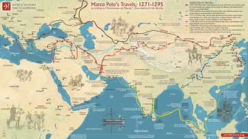
Map of Marco Polo’s Travels, 1271 - 1295
This map illustrates Marco Polo's travels (1271 - 1295), which spanned vast regions of Asia, including the Middle East, Central Asia, and China, where he served at the court of Kublai Khan. Polo journeyed along the Silk Road, encountering...
Image
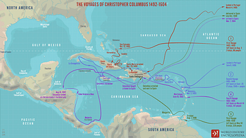
The Voyages of Christopher Columbus 1492-1504
A map illustrating the four voyages to the Americas of Christopher Columbus, a Genovese by origin, sailing under the flag of Spain. Although his intended mission was to discover a westward trade route to India, China, Japan, and the Spice...
Image
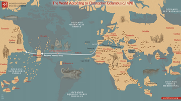
The World According to Columbus c. 1490
A map illustrating Christopher Columbus’s image of the world before his first voyage in 1492. It was based on a map by the Italian scholar Paolo dal Pozzo Toscanelli, which depicted the Earth as about 25% smaller than it actually is, exaggerated...
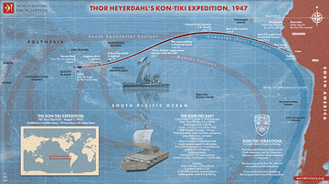
Image
Thor Heyerdahl’s Kon-Tiki Expedition, 1947
This map illustrates the route and story of the Kon-Tiki Expedition (1947), a groundbreaking voyage led by Thor Heyerdahl (1914-2002), in which a crew of six sailed a balsa-wood raft from Callao, Peru, to Raroia Atoll in the Tuamotu Islands...