
Search
Search Results
Image
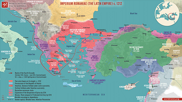
Division of the Byzantine Empire, 1204 CE.
This map illustrates the rise of the Latin Empire (Imperium Romaniae), a Crusader state founded by Western European forces after the Fourth Crusade's sack of Constantinople in 1204. It replaced the Byzantine Empire (Eastern Roman Empire...
Definition
Avars
The Avars were a confederation of heterogeneous (diverse or varied) people consisting of Rouran, Hephthalites, and Turkic-Oghuric races who migrated to the region of the Pontic Grass Steppe (an area corresponding to modern-day Ukraine, Russia...
Definition
Ancient Afghanistan
The ancient history of Afghanistan, a landlocked country in Central Asia, is full of fascinating cultures, from early nomadic tribes to the realms of Achaemenid Persia, the Seleucids, the Mauryans, the Parthians, and Sasanians, as well as...

Definition
Mesopotamian Government
Ancient Mesopotamian government was based on the understanding that human beings were created to help and serve the gods. The high priest, king, assembly of elders, governors, and any other officials were recognized as stewards chosen by...
Article
Women in Ancient Persia
Women in ancient Persia were not only highly respected but, in many cases, considered the equals of males. Women could own land, conduct business, received equal pay, could travel freely on their own, and in the case of royal women, hold...
Article
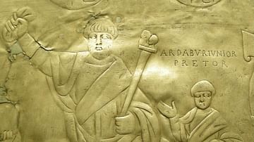
The Isaurians and the End of Germanic Influence in Byzantium
Germanic influence reigned in the Roman Empire from the end of the 4th century CE through the 5th. Germanic individuals took important posts in the government and the military, and Germanic tribes penetrated ever further into lands that had...

Definition
Sundiata Keita
Sundiata Keita (aka Sunjaata or Sundjata, r. 1230-1255) was the founder of the Mali Empire (1240-1645) in West Africa. A prince of the Malinke tribe, Sundiata would not only overthrow the rule of the kingdom of Sosso (c. 1180-1235), the biggest...

Definition
Mesopotamian Warfare
Ancient Mesopotamian warfare progressed from companies of a city's militia in Sumer to the professional standing armies of Akkad, Babylon, Assyria, and Persia and from conflicts over land or water rights to wars of conquest and political...
Definition
The Barracks Emperors
The “Barracks Emperors” is a term coined by later historians referring to the Roman emperors who were chosen and supported by the army during the period known as the Crisis of the Third Century (also known as the Imperial Crisis, 235-284...
Article
Achaemenid Kings List & Commentary
The Achaemenid Empire (c. 550-330 BCE) was the first great Persian political entity in Western and Central Asia which stretched, at its peak, from Asia Minor to the Indus Valley and Mesopotamia through Egypt. It was founded by Cyrus II (the...