
Search
Did you mean: Qin Dynasty?
Search Results

Image
Shang Dynasty of China, c. 1100 BCE
This map illustrates the rise and expansion of the Shang dynasty, which emerged around 1600 BCE after the fall of the Xia dynasty. Centered on the North China Plain, the Shang established a hereditary monarchy with a centralized government...
Definition
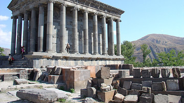
Ancient Armenia
Ancient Armenia, located in the south Caucasus area of Eurasia, was settled in the Neolithic era but its first recorded state proper was the kingdom of Urartu from the 9th century BCE. Incorporated into the Persian Empire of Cyrus the Great...
Definition
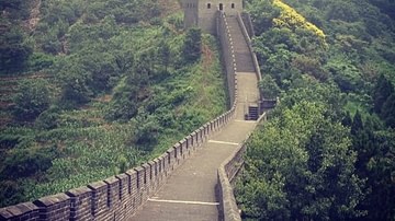
Great Wall of China
The Great Wall of China is a barrier fortification in northern China running west-to-east 13,171 miles (21,196 km) from the Jiayuguan Pass (in the west) to the Hushan Mountains in Liaoning Province in the east, ending at the Bohai Gulf. It...

3D Image
Great Jin Dynasty Bodhisattva
Bodhisattva, Shanxi Province, Jin Dynasty, circa 1200 CE, stone. Musée d’Art et d’Histoire (Musée du Cinquantenaire, Brussels, Belgium). Made with ReMake and ReCap Pro from AutoDesk. The Bodhisattva is the central figure of Mahayana Buddhism...
Image
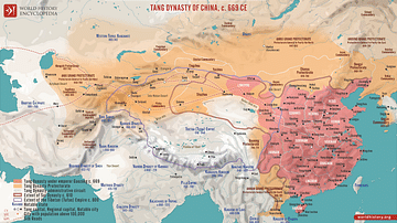
Tang Dynasty of China, c. 669 CE
A map illustrating the Tang Dynasty of China at its greatest extent under the rule of Emperor Gaozong, encompassing modern-day China, parts of Central Asia, and the Korean Peninsula. Around 669, the Empire reached its pinnacle of economic...

Article
The Mongol Invasion of Europe
The Mongol invasions of Russia and Eastern Europe occurred first with a brief sortie in 1223 CE and then again in a much larger campaign between 1237 CE and 1242 CE. The Mongols, seemingly coming from nowhere and quickly gaining a reputation...
Image
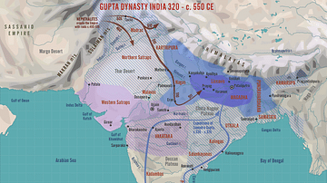
Gupta Dynasty India, 320 - c. 550 CE
A map illustrating the rise to power and expansion of the Gupta dynasty in India. Once rulers of the Magadha (now Bihar) kingdom, between the early 300s and mid-500s, they held an empire in northern and parts of central and western India...
Image
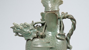
Celadon Fish-Dragon Ewer, Goryeo Dynasty
A celadon fish-dragon ewer. 12th century CE, Goryeo Dynasty, Korea. (National Museum of Korea, Soul, South Korea)
Image
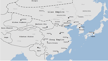
Liao Dynasty Map
A map indicating the territory controlled by the Liao dynasty (Khitans), 907-1125 CE.

Image
Delhi Sultanate under the Mamluk Dynasty, 1206-1290
This map illustrates the foundation and expansion of the Delhi Sultanate under the Mamluk Dynasty (also spelled Mameluke, Arabic: مملوك, mamlūk, meaning "one who is owned," a slave), which ruled northern India from 1206 to 1290. Established...