
Search
Remove Ads
Advertisement
Search Results

Image
19th-Century Ivory Traders, East Africa,
An 1880s photograph of ivory traders in East Africa.

Image
East India Company Trooper & Sepoy
An 1839 illustration showing a trooper and sepoy (Indian recruit) of the East India Company army. 27th Regiment of Madras Native Infantry. (British Library, London)

Image
Maji-Maji Rebellion, German East Africa
An early-20th-century painting by Wilhelm Kuhnert depicting German-led African Askari troops at the Battle of Mahenge during the Maji-Maji Rebellion (1905-7) against colonial rule in German East Africa.

Image
Dutch East India Company Logo
Blue and white Dutch East India Company (Vereenigde Oostindische Compagnie or VOC) logo from 1650-1674. Made in Japan to order by the company's directors in Batavia (Jakarta). Date between 1615 and 1674.

Image
Maryland, Dutch East Indies
A Swiss plantation in the Dutch East Indies bought in 1881 by Karl Krüsi (1855–1925) and named after Mary, his wife. In 1893, he sold it for a fortune and built the Villa Sumatra Zurich’s Sumatrastrasse. Manager House in Deli, Karl Krüsi...

Image
Pieter de Carpentier - Governor General of the Dutch East Indies
Pieter de Carpentier (1586-1659) - Governor General of the Dutch East Indies.

Article
Global Trade in the 13th Century
In the 13th century, astonishing quantities of spices and silk passed from the Far East to Europe. Exact amounts are not known, but spice popularity in both cuisine and medicine reached its historical peak during the Middle Ages in Europe...

Definition
Boston Tea Party
The Boston Tea Party was an act of political protest carried out by American colonists on 16 December 1773, in Boston, Massachusetts. Disguised as Mohawk Native Americans, the colonists dumped 342 crates of tea into Boston Harbor to protest...

Image
Map of the Roman Trade with the East, c. 1st–3rd Centuries - Silk Roads and Indian Ocean Routes across Afro-Eurasia
Roman trade with the East refers to the overland and maritime exchange networks that connected the Roman Empire with Parthian Iran, the Kushan Empire, India, Southeast Asia, Han China, and, from the 3rd century CE, the Sasanian Empire. During...
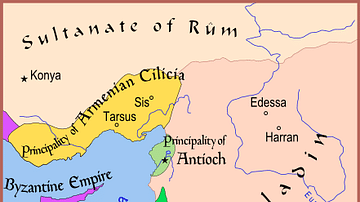
Image
Map of The Latin East, 1190 CE
A map of the Middle East showing the Crusader-held Latin East states at the time of the Third Crusade (1189-1192 CE).