
Search
Search Results
Image
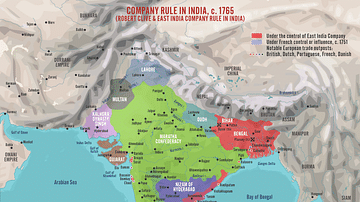
Robert Clive & The East India Company Rule in India, c. 1765
A map illustrating the transformation of the East India Company from a hopeful merchant venture in 1600 with isolated trade outposts governed by isolated and mostly independent town councils into a major ruler of large territories in India...
Image
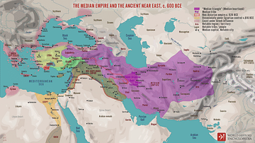
The Median Empire and the Ancient Near East, c. 600 BCE
A map illustrating the rise and expansion of the Median Empire in the wake of the Bronze Age Collapse and the disintegration of the Neo-Assyrian Empire (c. 609 BCE). While the Neo-Babylonian Empire engulfed the Fertile Crescent from the Levantine...
Image
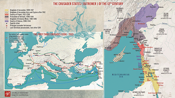
The First Three Crusades and the 12th-Century Latin East (Outremer)
Maps illustrating the trajectory of a series of early military campaigns initiated by the medieval Church between 1096–1192, aiming at liberating the "Holy Land" (roughly located between the Mediterranean Sea and the Eastern Bank of the Jordan...
Image
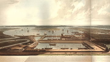
East India Docks
An 1808 coloured print showing the docks of the East India Company, known as the East India Docks, at Blackwall in London. (British Museum, London).
Image
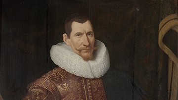
Jan Pieterszoon Coen, Governor General of the Dutch East Indies
Jan Pieterszoon Coen (1587-1629), an officer of the Dutch East India Company and twice the company's Governor-General in the Dutch East Indies, oil on wood portrait after Jacob Waben, 1629.
Westfries Museum, Hoorn, The Netherlands.

Image
Britannia Receiving the Riches of the East
A 1778 allegorical painting commissioned by the East India Company showing the riches of the East being presented to Britannia. Painted by Spyridon Romas. The goods shown include tea, porcelain, and jewels. (British Library, London)
Image
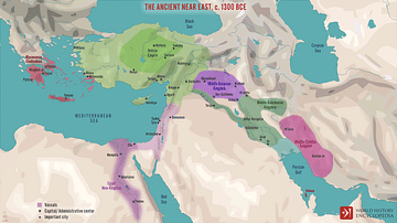
The Ancient Near East, c. 1300 BCE
A map illustrating the changing balance of power in the Ancient Near East in the 13th century BCE resulting from the expansion of the Hittite and Assyrian empires and the collapse of the Mittani kingdom.
Image
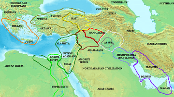
Map of the ancient Near East during the Amarna Period
Map of the ancient Near East during the Amarna Period, showing the great powers of the period: Egypt (green), Hatti (yellow), the Kassite kingdom of Babylon (purple), Assyria (grey), and Mittani (red). Lighter areas show direct control, darker...
Image
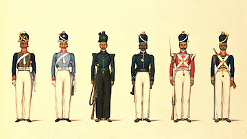
East India Company Madras Uniforms
A c. 1830 illustration by Yellapah of Vellore showing six Sepoy uniforms of the East India Company Madras army. From left to right: Madras Horse Artillery Madras Light Cavalry Madras Rifle Corps Madras Pioneers Madras Native Infantry...
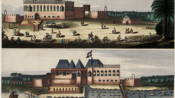
Image
East India Company Fort, Bombay
A c. 1665 illustration of the British East India Company's fort at Bombay (now Mumbai). (National Archives of the Netherlands, The Hague)