
Search
Remove Ads
Advertisement
Search Results

Image
Map of the Hadrian’s First Imperial Tour, 121–125 CE - Frontier Inspection, Hadrian’s Wall and Provincial Rule
Hadrian’s first great imperial tour (121–125 CE) transformed travel into an instrument of government across the Roman Empire. Leaving Rome in 121 CE, Hadrian...

Image
Map of the Ptolemaic Kingdom of Egypt c. 240 BCE - Power, Wealth, and Rivalry in the Hellenistic World
By c. 240 BCE, Ptolemaic Egypt stood as one of the most powerful and stable successor states of Alexander’s empire, reaching a high point under Ptolemy III Euergetes...
Image
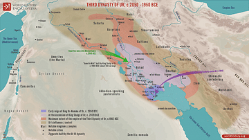
Map of the Third Dynasty of Ur - Sumerian Temples, Tablets, and the Birth of Legal Tradition in Ancient Mesopotamia
This map illustrates the rise of the Sumerian city-state of Ur following the collapse of the Akkadian Empire (reign: circa 2334 - 2154 BCE). In the...

Image
Map of the Trade Networks of the Roman Empire - Commerce & the Connectivity in the Mediterranean 1-3 c. CE
The prosperity of the Roman Empire (27 BCE-476 CE in the West) rested not only on military power and administration but also on an extensive network of maritime...

Image
Map of the Mauryan Empire, c. 321 - 185 BCE
A map illustrating the rise and expansion of the Mauryan empire, the first pan-Indian empire that covered most of India and parts of present-day Iran. Chandragupta Maurya, the first ruler, seized the opportunity...

Image
Map of the Spanish Empire and the Indies (c. 1500-1820)
The emergence of Spain as a global imperial power began with the dynastic union of the crowns of Castile and Aragon under Isabella I of Castile (reign 1474–1504) and Ferdinand II of Aragon (reign...

Image
The Acropolis and Ancient Athens
An image illustrating the evolution of the Athenian Acropolis (a fortified citadel and state sanctuary of the goddess Athena) and the city of Athens as it emerged from the devastation and ruin of the Greco-Persian...

Image
Map of the Carolingian Empire under Charlemagne, c. 814
The rise and expansion of the Carolingian dynasty (8th–early 9th centuries CE) reached its apex under Charlemagne (reigned 768–814 CE), son of Pepin the Short (reigned 751–768 CE) and grandson of...

Image
Map of the Indian Rebellion (Sepoy Mutiny) of 1857
The Indian Rebellion of 1857 was a transformative uprising that shook British rule in South Asia. Sparked in May 1857 by mutinous sepoys ((from Persian sepāhī, for soldier)) of the East India Company...

Image
Map of Roman North Africa - Provinces, Roads & Frontiers - Expansion, administration & economic foundations 146 BCE–395
Roman involvement in North Africa began with the destruction of Carthage in the Third Punic War (149-146 BCE), after which Rome established the...
