
Search
Search Results
Image
Norse America: The Story of a Founding Myth by Gordon Campbell
Cover of Norse America: The Story of a Founding Myth by Gordon Campbell. Published by Oxford University Press.
Image
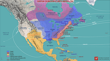
European Colonization of North America c.1750
A map illustrating the process of systematic European colonization of North America during the Age of Exploration - from the 1490s until the start of the French and Indian War of 1750s. It also depicts the shift of balance of power in the...
Image
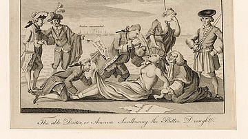
The Able Doctor, or America Swallowing the Bitter Draught
A political cartoon meant to protest the Intolerable Acts of 1774; it depicts a Mohawk woman, representing America, held down and force-fed tea by a man labeled as 'the Boston Port Act'. From Emmet Collection of Manuscripts Etc. Relating...
Image
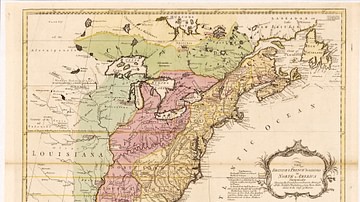
English & French Colonies in North America, 1758 CE
Map of English and French colonies in North America c. 1758 CE. English-controlled colonies are shown in yellow, French colonies in green, and disputed territories in red. Collection of the Library of Congress, Washington, D.C.
Image
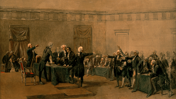
The Declaration of Independence of the United States of America
The Declaration of Independence of the United States of America, July 4, 1776, oil on canvas by Charles Édouard Armand-Dumaresq, c. 1873.
White House Cabinet Room, Washington, D.C.
Image
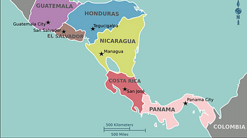
Modern Map of Central America
A map of modern Central America.
Article
Origins of World Agriculture
Agriculture arose independently at several locations across the world, beginning about 12,000 years ago. The first crops and livestock were domesticated in six rather diffuse areas including the Near East, China, Southeast Asia, and Africa...

Definition
European Colonization of the Americas
The European colonization of the Americas was the process by which European settlers populated the regions of North, Central, South America, and the islands of the Caribbean. It is also recognized as the direct cause for the cultures of the...

Video
The Dangerous Race for the South Pole - Elizabeth Leane
View full lesson: https://ed.ted.com/lessons/the-dangerous-and-daring-race-for-the-south-pole-elizabeth-leane By the early 1900’s CE, nearly every region of the globe had been visited and mapped, with only two key locations left: the North...

Video
The South Italic Cuirass
Dr Mike Burns speaks about The South Italic cuirass from the 6th to 3rd centuries BC at the Greek and Roman Armour Day, 20th July, 2015.