
Search
Remove Ads
Advertisement
Search Results

Image
Map of the Trade Networks in the Middle Ages, c. 1200
By the early 13th century (c. 1200 CE), long-distance trade networks across Eurasia and the Mediterranean had regained a level of interconnectivity not seen since late antiquity. After the political fragmentation that followed the fall of...

Article
European Discovery & Conquest of the Spice Islands
Clove, nutmeg, and mace are native to only a handful of tiny islands in the middle of the vast Indonesian archipelago – cloves on five Maluku Islands (the Moluccas) about 1250 km (778 mi) west of New Guinea, and nutmeg on the ten Banda Islands...

Image
Map of the Roman Trade with the East, c. 1st–3rd Centuries - Silk Roads and Indian Ocean Routes across Afro-Eurasia
Roman trade with the East refers to the overland and maritime exchange networks that connected the Roman Empire with Parthian Iran, the Kushan Empire, India, Southeast Asia, Han China, and, from the 3rd century CE, the Sasanian Empire. During...

Image
Map of European Expansion and Global Trade Empires, c.1700
By the 18th century, European power had become truly global through a combination of maritime expansion, state-backed commerce, and military force. The leading Atlantic empires, Spain, Portugal, the Dutch Republic, England, and France, had...
Image
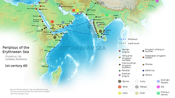
Ancient Indian Maritime Trade Routes
This map is derived from the book Periplus of the Erythraean Sea. It depicts trade routes in the ancient world, ports in the Chera territory and other parts of India and the trade routes connecting them to other parts of the world along with...

Definition
Songhai Empire
The Songhai Empire (aka Songhay, c. 1460 - c. 1591) covered what is today southern Mauritania and Mali. It replaced the Mali Empire (1240-1645) as the most important state in West Africa. Originating as a smaller kingdom along the eastern...

Image
Transatlantic Triangular Trade Map
Map showing the flow of goods and enslaved people across the Atlantic between Europe, Africa and America in the transatlantic triangular trade which the European colonial powers operated from the 16th to the 19th centuries CE. This triangular...

Video
Roman Trade with Africa DOCUMENTARY
We are continuing our new animated historical documentary series on the Roman trade and economy with a video on the trade with Africa. Previously we have covered the Roman trade with India https://www.youtube.com/watch?v=eDTaOOVbxLs and the...

Image
Map of Medieval Japanese Trade & Wako Pirates
Map depicting Medieval Japan and its trade relations with its neighbours, China and Korea. The map shows the major trade goods exchanged between Japan, China, and Korea. Black lines show the approximate routes taken by the Wako Pirates. Each...

Definition
Wolof Empire
The Wolof (aka Jolof or Djolof) Empire was a state on the coast of West Africa, located between the Senegal and Gambia rivers, which thrived from the mid-14th to mid-16th century CE. The empire prospered on trade thanks to the two rivers...