
Search
Remove Ads
Advertisement
Search Results
Article
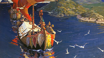
Trade & Warfare in the Kievan Rus
Scandinavians from the island of Gotland began to spread throughout the Baltic region along the Russian rivers in the 700s. While the Vikings of Norway and Denmark from the 8th to 11th centuries are widely recognized as fearsome raiders and...

Worksheet/Activity
Trade in the Roman Empire - Web Quest & Map Skills
This activity has been designed to fit a 20-30-minute slot for your class and is suitable for both online and classroom teaching. Students have to do a web quest in order to complete a map. It is part of our Roman Economy and Trade pack...

Definition
Ferdinand Magellan
Ferdinand Magellan, or Fernão de Magalhães (c. 1480-1521), was a Portuguese mariner whose expedition was the first to circumnavigate the globe in 1519-22 in the service of Spain. Magellan was killed on the voyage in what is today the Philippines...

Definition
Portuguese Cochin
Cochin, located on the southwest coast of India, was a Portuguese colony from 1503 to 1663. Known to the Portuguese as Cochim, it was one of several important cities on India’s Malabar Coast and a great trade centre for spices like pepper...

Image
Map Showing William Dampier's 1699 Expedition Route
Map showing William Dampier's expedition along the west and northwest coast of New Holland (Australia) and the coasts of Timor, New Guinea and New Britain in 1699 aboard the HMS Roebuck.

Collection
Trade in the Middle Ages
Peoples, cities and states have traded since antiquity but in the medieval period, things escalated so that goods travelled ever greater distances by land, river and sea. Great cities arose thanks to commerce and international trade such...

Lesson Pack
Geography, Economy, & Trade in Ancient Egypt
We have prepared three lesson plans including classroom activities, assignments, homework, and keys as well as: - Multiple choice quiz questions in an excel format. - Glossary of keywords and concepts in an excel format. - Open questions...

Collection
Ancient China: Geography, Economy & Trade
Ancient China was often connected to the rest of the world through trade, not only along the famous Silk Road but also via merchant ships that sailed the Indian Ocean, connecting East Asia to the Middle East, Europe, and Africa. Silk, paper...

Article
Cultural Links between India & the Greco-Roman World
Cyrus the Great (558-530 BCE) built the first universal empire, stretching from Greece to the Indus River. This was the famous Achaemenid Empire of Persia. An inscription at Naqsh-i-Rustam, the tomb of his able successor Darius I (521-486...

Lesson Pack
Roman Economy & Trade
We have prepared three lesson plans including classroom activities, assignments, homework, and keys as well as: - Glossary of keywords and concepts in an excel format - Open questions adaptable for debates, presentations, and essays...