
Search
Search Results
Definition
Periplus of the Erythraean Sea
The Periplus of the Erythraean Sea is an eyewitness account of ancient travel to Africa and India via the Red Sea written by an unknown Greek-speaking Egyptian author in the 1st century CE. In this detailed account, the conditions of the...

Video
The Silk Road and Ancient Trade: Crash Course World History #9
The Silk Road and Ancient Trade: In which John Green teaches you about the so-called Silk Road, a network of trade routes where goods such as ivory, silver, iron, wine, and yes, silk were exchanged across the ancient world, from China to...
Definition
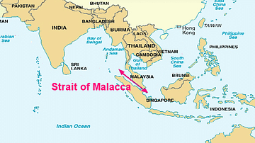
Portuguese Malacca
The Portuguese colonised Malacca (modern Melaka) on the southwest coast of the Malay peninsula from 1511 and kept it until 1641 when the Dutch took over. The port controlled the Malay Straits which lead from the Indian Ocean (the Andaman...

Video
Roman Trade with Africa DOCUMENTARY
We are continuing our new animated historical documentary series on the Roman trade and economy with a video on the trade with Africa. Previously we have covered the Roman trade with India https://www.youtube.com/watch?v=eDTaOOVbxLs and the...
Image
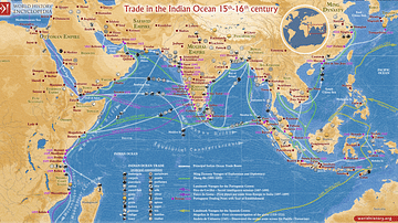
Trade in the Indian Ocean 15th-16th century
This map illustrates the Indian Ocean trade (15th–16th centuries), a vast maritime network linking East Africa, the Middle East, South Asia, and Southeast Asia, facilitating the exchange of spices, textiles, metals, timber, and luxury goods...

Article
The Camel Caravans of the Ancient Sahara
The camel caravans which crossed the great dunes of the Sahara desert began in antiquity but reached their golden period from the 9th century CE onwards. In their heyday caravans consisted of thousands of camels travelling from North Africa...
Article
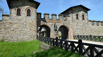
A Visitor's Guide to Rome's Frontier in Germany
In the 2nd century CE, the Roman Empire stretched from Scotland in northern Europe to the deserts of southern Egypt, encompassing the entirety of the Mediterranean basin. Beyond that lay its borders. Where there was no natural frontier such...

Image
The East India Company Trade, c. 1800
A map illustrating the markets and goods traded by the East India Company (EIC) with East and Southeast Asia and India around 1800. Incorporated on December 31, 1600, by Queen Elizabeth I's Royal Charter, it was given an initial 15-year monopoly...

Image
Transatlantic Triangular Trade Map
Map showing the flow of goods and enslaved people across the Atlantic between Europe, Africa and America in the transatlantic triangular trade which the European colonial powers operated from the 16th to the 19th centuries CE. This triangular...
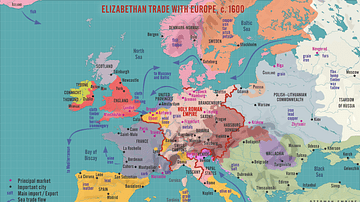
Image
Elizabethan Trade with Europe, c. 1600
A map illustrating the flourishing English trade with Europe during the reign of Queen Elizabeth I of England (r. 1558-1603). Following the abolishment of the Hanseatic merchants' Baltic monopoly, access to a new commodities market in Amsterdam...