
Search
Did you mean: Bes?
Remove Ads
Advertisement
Search Results

Article
Zengids & the Crusaders: Race for Egypt (1163-1169 CE)
In the aftermath of the failure of the Second Crusade (1147-1149 CE), which only managed to bring Damascus under Nur ad-Din's (sometimes also given as Nur al-Din, l. 1118-1174 CE) dominion, Egypt acquired top priority – both from a strategic...

Article
The Siege of Damascus, 1148 CE
The siege of Damascus in 1148 CE was the final act of the Second Crusade (1147-1149 CE). Lasting a mere four days from 24 to 28 July, the siege by a combined western European army was not successful, and the Crusade petered out with its leaders...

Collection
The Norman Conquest of 1066 CE
The Norman Conquest entirely changed the history of England from 1066 CE onwards. After Harold II's defeat and death at the Battle of Hastings in 1066 CE, William the Conqueror was made the new king, the Norman elite completely replaced the...
Image
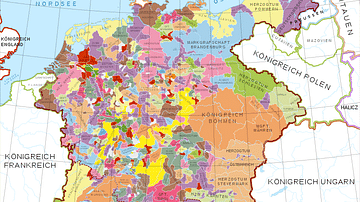
Holy Roman Empire in the 13th century CE
A map in German of central Europe during the time of the Hohenstaufen Emperors, primarily showing the territories of the Holy Roman Empire and the Kingdom of Sicily. The map is a vectorised version of this map from Professor G. Droysens...

Image
Map of the Journeys of Paul the Apostle, c. 46-63 CE - Spread of Early Christianity Across the Roman Mediterranean
The journeys of Paul the Apostle, also known as Saul of Tarsus, unfolded during the mid-1st century CE within the highly interconnected world of the Roman Empire under Claudius (reign 41-54 CE) and Nero (reign 54-68 CE). One of the earliest...
Image
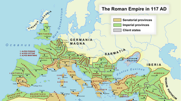
Roman Empire in 117 CE
Map of the Roman Empire at its maximum extent in 117 CE, under the rule of Trajan.

Image
Map of the Tang Dynasty of China, c. 669 CE
The Tang Dynasty (618–907 CE) represents one of the high points of imperial Chinese history, reaching its widest territorial extent during the reign of Emperor Gaozong (reign 649–683 CE). By the late 7th century, around 669 CE, the empire...
Image
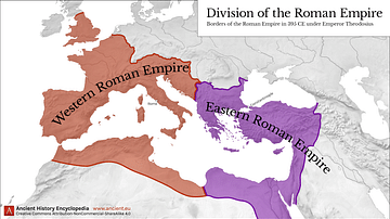
Western & Eastern Roman Empire, 395 CE
This map shows the division of the Roman Empire into the Western Roman Empire and the Eastern Roman Empire, circa 395 CE under the reign of Emperor Theodosius I.
Image
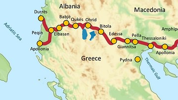
Via Egnatia, 146 BCE to c. 1200 CE
Via Egnatia was a major Roman road in the Balkans, stretching 1,120 kilometers (696 miles) from the Adriatic Sea in the west to the Black Sea and the Sea of Marmara in the east. The western terminus is slightly uncertain, often marked in...

Image
Map of the Sassanid Empire c. 620 CE - Persia’s Last Great Imperial Power
The Sasanian Empire (224–651 CE), known in Middle Persian sources as Ērānshahr (“Realm of the Iranians”), emerged as the final pre-Islamic Persian imperial state and a major power of Late Antiquity. Founded by Ardashir I (reign 224–242 CE...