
Search
Did you mean: Bes?
Remove Ads
Advertisement
Search Results

Image
Roman Province Bithynia et Pontus c. 200 CE
The Roman province of Bithynia et Pontus, established in 63 BCE after the defeat of Mithridates VI of Pontus, was a prosperous and strategically significant region by 200 CE. Located in northern Anatolia along the southern Black Sea coast...
Image
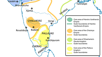
Ancient India in 625 CE
This is a political map of India showing the important kingdoms that existed around 625 CE. The predominant powers are the Pushyabhutis under Emperor Harshavardhana or Harsha (606-647 CE) in northern India, the (Vatapi) Chalukyas under Emperor...

Image
Map of the Middle East during the Second Fitna (c. 686 CE)
A map depicting the divisions of the Islamic Empire during the second Islamic civil war - the Second Fitna. The dominions of the Umayyads, Zubayrids, Kharjites, Al Mukhtar and those regained by the Byzantines are shaded in colors as indicated...

Image
Paul the Apostle's First Missionary Journey (c. 46-48 CE)
Paul the Apostle undertook multiple missionary journeys across the Roman Empire to spread Christianity, establish churches, and strengthen the faith of early Christians. Paul's first missionary journey, accompanied by Barnabas and John Mark...

Image
Paul the Apostle's Second Missionary Journey (c. 49-52 CE)
Paul the Apostle undertook multiple missionary journeys across the Roman Empire to spread Christianity, establish churches, and strengthen the faith of early Christians. Paul's second missionary journey, accompanied by Silas and later joined...

Image
English Medieval Clothing, c. 1300 CE
An illustration of the typical clothing worn in 14th century CE England. ('Costumes of all Nations', 1882 CE)
Image
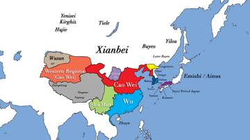
Three Kingdoms Period of China and the Rise of Xianbei in the year 229 CE
This map depicts the boundaries of all major civilizations in East Asia at the beginning of the Three Kingdoms Period of China, with italics indicating nomadic bands and other tribal societies. Following the collapse of Han Dynasty in 220...

Image
Map of the Roman Empire under the Flavians (69–96 CE) - Stability after Civil War
The territorial organization of the Roman Empire at the close of the Flavian dynasty (69–96 CE) reflects a period of consolidation following the political crisis that ended the Julio-Claudian line. After the turmoil of the Year of the Four...
Image
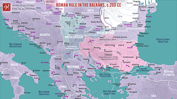
Roman Rule in the Balkans, c. 200 CE
A map illustrating Roman rule in the Balkans around 200 CE, characterized by significant administrative, military, and cultural integration into the Empire. The region was divided into several provinces (Moesia Superior, Moesia Inferior...
Image
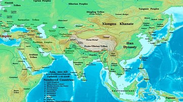
Map of the Eastern Hemisphere (1 CE)
Map showing the political division in the Eastern hemisphere in 1 CE. The Han dynasty was almost at its peak in terms of geographical expansion.