
Search
Did you mean: Bes?
Remove Ads
Advertisement
Search Results

Image
Map of the Year of the Four Emperors, 69 CE
The Year of the Four Emperors (69 CE) was a moment of deep instability in the Roman Empire, marked by the rapid succession of Galba (June 68–January 69 CE), Otho (January–April 69 CE), Vitellius (April–December 69 CE), and Vespasian (69–79...

Image
Kingdom of Kush (c. 2400 BCE - 350 CE)
Map of the Kingdom of Kush (c. 2400 BCE - 350 CE), showing the location of major cities, Kushite pyramids, and trade routes in what is now modern Sudan. Kush's close proximity to Egypt saw trade and cultural exchange as early as 2400 BCE...
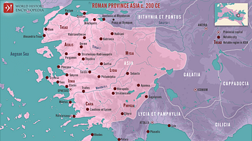
Image
Roman Province Asia c. 200 CE
This map illustrates the Roman province of Asia around 200 CE. Established in 129 BCE following the bequest of the Attalid Kingdom of Pergamon to Rome, it encompassed western Anatolia (modern-day Turkey). It was a wealthy and vibrant region...

Image
Map of Diaspora Synagogues (1st - 2nd centuries CE)
This map illustrates the geographic spread of Jewish communities and synagogues across the Roman and Parthian worlds during the 1st and 2nd centuries CE. It highlights the development of Jewish life in the Diaspora following centuries of...

Image
Map of the Byzantine Empire in 1025 CE
Map of the provinces of the Byzantine Empire in 1025 CE.

Image
Major Temples and Shrines of Japan circa 1200 CE, Kamakura Shogunate
This map depicts all major Buddhist temples and Shinto shrines of Japan around the year 1200 CE. Notice that many renowned temples (such as the famous Kinkaju-ji) have not yet been built at that time. The map highlights the city of Kamakura...
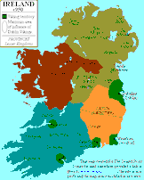
Image
Map of Ireland c. 950 CE
Map of Ireland around 950 CE, showing both the local Irish kingdoms and the Viking territories. Map credited to www.irelandhistory.com

Image
13th Century CE Roll of Arms
The oldest known English roll of arms, dating to c. 1244 CE. It is a single sheet painted on both sides by Mathew Paris and showing 75 coats of arms starting with the king’s. (British Library, London)

Image
Fragmentation of the Abbasid Empire (891-892 CE)
A map showing various territories that were carved up by local rulers in the late 9th Century CE, either under the suzerainty of the Abbasid Dynasty or in rebellion against the Abbasid Empire.
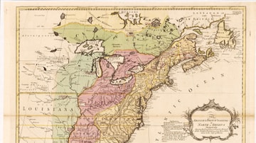
Image
English & French Colonies in North America, 1758 CE
Map of English and French colonies in North America c. 1758 CE. English-controlled colonies are shown in yellow, French colonies in green, and disputed territories in red. Collection of the Library of Congress, Washington, D.C.