
Search
Search Results

Image
The Feudal Society in Medieval Europe
An illustration depicting the strict hierarchical structure of the societies of Western Europe in the Middle Ages (c.10th-13th century) based on a tenement-based distribution of the land into units or "fiefs." During a period commonly known...
Image
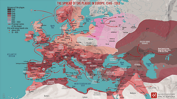
The Spread of the Plague in Europe, 1346 - 1353
A map illustrating the rapid spread of the 14th-century plague pandemic commonly known as the "Black Death", across Europe and the Middle East. The second such pandemic (after the 541 - 549 outbreak during the reign of the Roman emperor Justinian...
Image
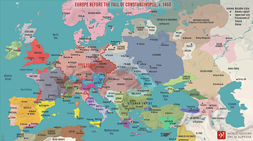
Europe Before the Fall of Constantinople, c. 1450
A map illustrating the political situation in Europe, East Asia, the Middle East, and North Africa around 1450, just before the fall of Constantinople, the expansion of the Ottoman Empire under Mehmed II, the Conqueror, and the transformation...
Image
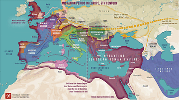
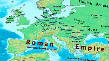
Migration Period in Europe During the 4th & 5th Century
A map illustrating migrations of various peoples across fractured Europe and Western Asia after the division of the Roman Empire at the end of the 4th Century CE.

Image
Europe at the Peace of Westphalia, 1648
A map illustrating the situation in Europe after the Peace of Westphalia was signed in Osnabrück and Münster between May and October 1648. The two treaties ended the Thirty Years’ War (initially a war between various Protestant and Catholic...
Image
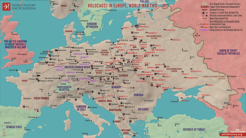
Holocaust in Europe during World War Two
This map illustrates the scale and scope of the Holocaust in Europe during World War II, a systematic, state-organized persecution and murder of approximately six million Jews, alongside millions of other victims, by Nazi Germany and its...
Image
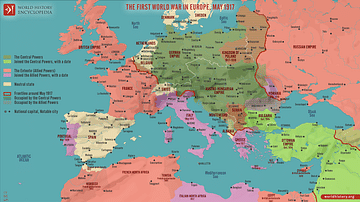
The First World War in Europe, May 1917
A map illustrating the situation in Europe around May 1917, during the First World War (World War I or The Great War), as the conflict had already raged on for nearly three years. The United States had recently entered the war, beginning...
Image
Map of Europe, 400 CE
Map of Europe in 400 CE
Image
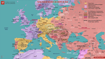
Totalitarian Regimes in Europe in 1939
This map illustrates the geopolitical situation in Europe in the lead-up to the Second World War (1939-45) as authoritarianism and totalitarianism were on the rise across the continent, fueled by political instability, economic crises, and...
Image
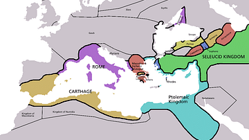
Map of Europe in 220 BC
Approximate borders in Europe around 220 BC. Based on the Pengiun Atlas of History.