
Search
Did you mean: Trajan?
Search Results

Video
Trade in Ancient Greece
In the video below, Museum of Fine Arts curator Phoebe Segal explains how ancient coins tell us about the trade routes and economic patterns of their time. For more CitiesX content, sign-up for the course on edX: https://www.edx.org/course/citiesx-past-present-future-urban-life-harvardx-urban101x...

Video
Trade and Economics in the Middle Ages
The history of medieval trade.
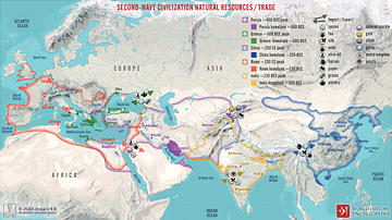
Image
Second-Wave Civilization Natural Resources and Trade
A map illustrating the rise and spread of the Second Wave Civilizations between c. 500 BCE and 200 CE (including the Persians, the Greeks, the Romans, the Chinese, and India) with the flows of trade in major goods and resources.
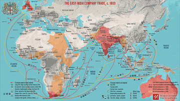
Image
The East India Company Trade, c. 1800
A map illustrating the markets and goods traded by the East India Company (EIC) with East and Southeast Asia and India around 1800. Incorporated on December 31, 1600, by Queen Elizabeth I's Royal Charter, it was given an initial 15-year monopoly...
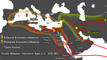
Image
Hellenistic Trade Routes, 300 BCE
Alexander the Great died in Babylon on the 13th of June, 323 BCE. His Macedonian-Greek empire broke apart, but Alexander’s heritage was felt throughout the ancient Mediterranean world for centuries. Three Hellenic empires emerged from the...
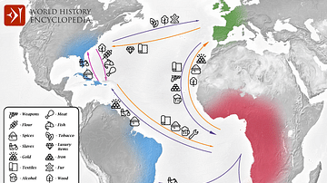
Image
Transatlantic Triangular Trade Map
Map showing the flow of goods and enslaved people across the Atlantic between Europe, Africa and America in the transatlantic triangular trade which the European colonial powers operated from the 16th to the 19th centuries CE. This triangular...
Image
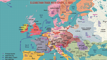
Elizabethan Trade with Europe, c. 1600
A map illustrating the flourishing English trade with Europe during the reign of Queen Elizabeth I of England (r. 1558-1603). Following the abolishment of the Hanseatic merchants' Baltic monopoly, access to a new commodities market in Amsterdam...
Image
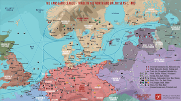
The Hanseatic League - Trade in the North and Baltic Seas c. 1400
A map illustrating the expanse and complexity of the northern Europen trade network of commerce and the powerful association of cities and merchant guilds known as the Hanseatic League (from Old High German - Hanse for “guild,” or “association,”...
Image
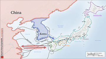
Map of Medieval Japanese Trade & Wako Pirates
Map depicting Medieval Japan and its trade relations with its neighbours, China and Korea. The map shows the major trade goods exchanged between Japan, China, and Korea. Black lines show the approximate routes taken by the Wako Pirates. Each...
Image
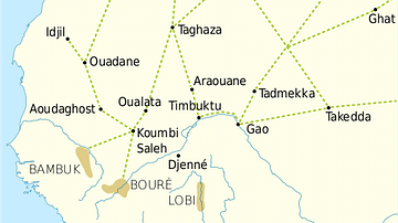
Trans-Saharan Trade Routes
A map indicating the major trans-Saharan trade routes across West Africa c. 1100-1500 CE. The darker yellow areas indicate gold fields.