
Search
Search Results

Definition
Timbuktu - West Africa's Great Trading Centre
Timbuktu (Timbuctoo) is a city in Mali, West Africa which was an important trade centre of the Mali Empire which flourished between the 13th and 15th centuries. The city, founded c. 1100, gained wealth from access to and control of the trade...

Video
Sacred Sites and Pilgrimage Routes in the Kii Mountain Range (UNESCO/NHK)
Set in the dense forests of the Kii Mountains overlooking the Pacific Ocean, three sacred sites – Yoshino and Omine, Kumano Sanzan, Koyasan – linked by pilgrimage routes to the ancient capital cities of Nara and Kyoto, reflect the fusion...
Image
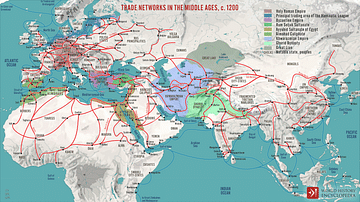
Trade Networks in the Middle Ages, c. 1200
A map illustrating the interconnectivity and extent of the global trade networks at the onset of the 13th century after the centuries of decline and isolation following the collapse of the Western Roman Empire. The conditions were beginning...
Definition
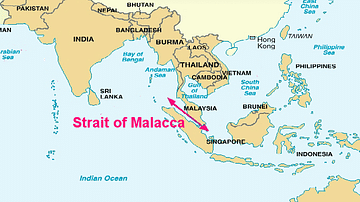
Portuguese Malacca
The Portuguese colonised Malacca (modern Melaka) on the southwest coast of the Malay peninsula from 1511 and kept it until 1641 when the Dutch took over. The port controlled the Malay Straits which lead from the Indian Ocean (the Andaman...
Image
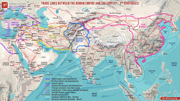
Trade Links between the Roman Empire and the East (1st - 3rd centuries)
A map illustrating the ever-growing and ever-changing trade network of maritime and overland routes connecting China, India, and the Far East with the Middle East and Europe. Even though the term "Silk Road" was not defined until the late...

Video
The Silk Road and Ancient Trade: Crash Course World History #9
The Silk Road and Ancient Trade: In which John Green teaches you about the so-called Silk Road, a network of trade routes where goods such as ivory, silver, iron, wine, and yes, silk were exchanged across the ancient world, from China to...
Image
Trade in the Roman Empire Map (c. 200 CE)
This map shows the major sources of trade goods in the Roman Empire, circa 200 CE. The map shows the sources of the following trade goods: grain, olive oil, slaves, wine, metals, textiles and wild animals.
Image
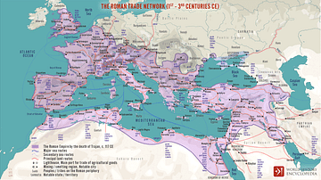
The Roman Trade Network (1st - 3rd centuries CE)
A map illustrating the principal trade routes of overseas and transregional exchange of goods across the Roman Empire between the first and third centuries. The depiction is schematic not only for the completeness of adequate historical knowledge...

Definition
Fertile Crescent
The Fertile Crescent, often called the "Cradle of Civilization", is the region in the Middle East which curves, like a quarter-moon shape, from the Persian Gulf, through modern-day southern Iraq, Syria, Lebanon, Jordan, Israel and northern...
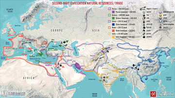
Image
Second-Wave Civilization Natural Resources and Trade
A map illustrating the rise and spread of the Second Wave Civilizations between c. 500 BCE and 200 CE (including the Persians, the Greeks, the Romans, the Chinese, and India) with the flows of trade in major goods and resources.