
Search
Search Results
Image
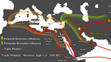
Hellenistic Trade Routes, 300 BCE
Alexander the Great died in Babylon on the 13th of June, 323 BCE. His Macedonian-Greek empire broke apart, but Alexander’s heritage was felt throughout the ancient Mediterranean world for centuries. Three Hellenic empires emerged from the...
Image
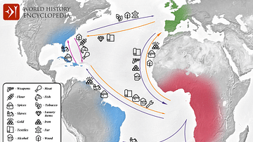
Transatlantic Triangular Trade Map
Map showing the flow of goods and enslaved people across the Atlantic between Europe, Africa and America in the transatlantic triangular trade which the European colonial powers operated from the 16th to the 19th centuries CE. This triangular...
Image
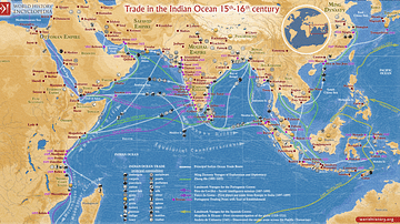
Trade in the Indian Ocean 15th-16th century
This map illustrates the Indian Ocean trade (15th–16th centuries), a vast maritime network linking East Africa, the Middle East, South Asia, and Southeast Asia, facilitating the exchange of spices, textiles, metals, timber, and luxury goods...
Image
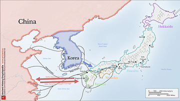
Map of Medieval Japanese Trade & Wako Pirates
Map depicting Medieval Japan and its trade relations with its neighbours, China and Korea. The map shows the major trade goods exchanged between Japan, China, and Korea. Black lines show the approximate routes taken by the Wako Pirates. Each...
Image
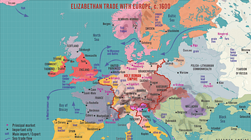
Elizabethan Trade with Europe, c. 1600
A map illustrating the flourishing English trade with Europe during the reign of Queen Elizabeth I of England (r. 1558-1603). Following the abolishment of the Hanseatic merchants' Baltic monopoly, access to a new commodities market in Amsterdam...
Image
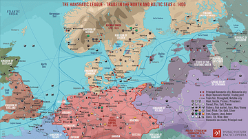
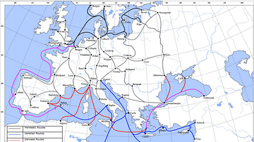
The Hanseatic League - Trade in the North and Baltic Seas c. 1400
A map illustrating the expanse and complexity of the northern Europen trade network of commerce and the powerful association of cities and merchant guilds known as the Hanseatic League (from Old High German - Hanse for “guild,” or “association,”...
Definition
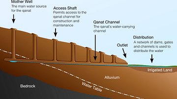
Qanat
The qanat (called foggara in North Africa and the Levant, falaj in the United Arab Emirates and Oman, kariz in Iran, and puquios in Peru) is an ancient Middle Eastern irrigation technique in which a long tunnel is dug into arid land that...
Image
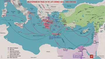
Mediterranean Trade in the Late Bronze Age c. 1400-1200 BCE
A map illustrating the late Bronze Age trade in the eastern Mediterranean seaboard as a region of increasing connectivity between the key players Pharaonic Egypt in the south, the Hittite Empire, Mesopotamia, and the Levant to the east, and...
Image
Late Medieval Land & Maritime Trade Routes
A map showing the late medieval trade routes by land and sea across Europe and Western Asia.
Image
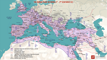
The Roman Trade Network (1st - 3rd centuries CE)
A map illustrating the principal trade routes of overseas and transregional exchange of goods across the Roman Empire between the first and third centuries. The depiction is schematic not only for the completeness of adequate historical knowledge...