
Search
Search Results
Image
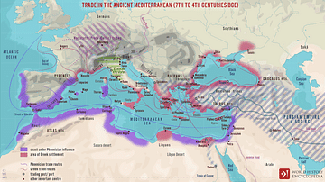
Trade Routes in the Ancient Mediterranean
A map illustrating the boundaries, spheres of influence, and the flow of trade around the Mediterranean Sea between the 7th and 4th centuries BCE.
Image
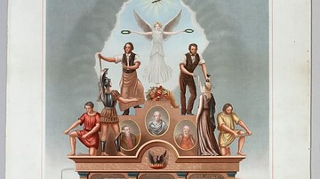
Trade Union Scroll for the Amalgamated Society of Engineers
A trade union scroll for the Amalgamated Society of Engineers, created in January 1851. The scroll shows illustrations of important engineers and inventions during the Industrial Revolution. (Science Museum, London)

Quiz
Roman Trade & Economy
Roman economy trade Amphora, Amphorae Argentarii Commerce Free Market Economy Garum Mensarii Mint Nummularii Pax Romana Princeps State-Controlled Economy Veto
Image
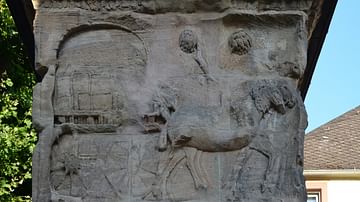
Relief Showing a Scene of Cloth Trade
Relief from the Igel Column depicting mules pulling a four-wheeled chariot cart laden transporting bales of cloth. The Igel Column is a multi-storey Roman sandstone funerary monument located on the left bank of the Moselle some eight kilometres...

Video
Roman Trade with Africa DOCUMENTARY
We are continuing our new animated historical documentary series on the Roman trade and economy with a video on the trade with Africa. Previously we have covered the Roman trade with India https://www.youtube.com/watch?v=eDTaOOVbxLs and the...

Video
Int'l Commerce, Snorkeling Camels, and The Indian Ocean Trade: Crash Course World History #18
In which John Green teaches you the history of the Indian Ocean Trade. John weaves a tale of swashbuckling adventure, replete with trade in books, ivory, and timber. Along the way, John manages to cover advances in seafaring technology, just...
Image
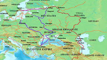
Varangian Trade Routes
Map showing Varangian trade routes.
Red: Volga trade route
Purple: trade route from the Varangians to the Greeks
Orange: Other trade routes of the 8th-11th centuries

Video
History of the Major Trade Routes - Summary on a Map
In this video, let's retrace the evolution of the world’s major trade routes, from the Incense Route until today.
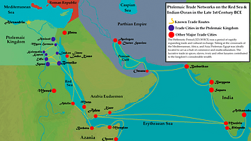
Image
Ptolemaic Trade Networks in the Late 1st Century BCE
This map illustrates the trading networks which connected the Ptolemaic Kingdom to South Asia and East Africa by the second half of the 1st century BCE. During this time period, Ptolemaic Egypt was a major player in the spice trade which...
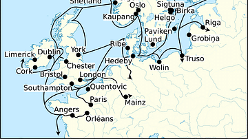
Image
Viking Age Trade Routes in North-West Europe
Map showing some of the Viking Age (c. 790-1100 CE) trade routes that existed in North-West Europe during this time. Among the places depicted are such major trading centres are Hededy, Ribe, Birka and Kaupang from Viking Scandinavia; York...