
Search
Search Results
Image
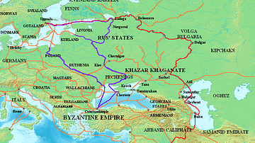
Varangian Trade Routes
Map showing Varangian trade routes.
Red: Volga trade route
Purple: trade route from the Varangians to the Greeks
Orange: Other trade routes of the 8th-11th centuries
Article
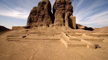
Interrelations of Kerma and Pharaonic Egypt
The vacillating nature of Ancient Egypt's associations with the Kingdom of Kerma may be described as one of expansion and contraction; a virtual tug-of-war between rival cultures. Structural changes in Egypt's administration led to alternating...

Video
The Silk Road and Ancient Trade: Crash Course World History #9
The Silk Road and Ancient Trade: In which John Green teaches you about the so-called Silk Road, a network of trade routes where goods such as ivory, silver, iron, wine, and yes, silk were exchanged across the ancient world, from China to...

Video
Roman Trade with Africa DOCUMENTARY
We are continuing our new animated historical documentary series on the Roman trade and economy with a video on the trade with Africa. Previously we have covered the Roman trade with India https://www.youtube.com/watch?v=eDTaOOVbxLs and the...

Image
Western Sahara, Catalan Atlas
A map of West Africa from the 1375 CE Catalan Atlas. The map shows the trans-Saharan caravan trade routes between North Africa and the Niger River. (Sheet 6, National Library of France, Paris)
Image
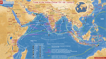
Trade in the Indian Ocean 15th-16th century
This map illustrates the Indian Ocean trade (15th–16th centuries), a vast maritime network linking East Africa, the Middle East, South Asia, and Southeast Asia, facilitating the exchange of spices, textiles, metals, timber, and luxury goods...
Definition
Kingdom of Axum
The African kingdom of Axum (also Aksum) was located on the northern edge of the highland zone of the Red Sea coast, just above the horn of Africa. It was founded in the 1st century CE, flourished from the 3rd to 6th century CE, and then...
Definition
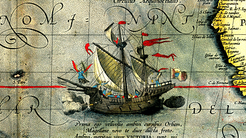
Ferdinand Magellan
Ferdinand Magellan, or Fernão de Magalhães (c. 1480-1521), was a Portuguese mariner whose expedition was the first to circumnavigate the globe in 1519-22 in the service of Spain. Magellan was killed on the voyage in what is today the Philippines...

Image
The East India Company Trade, c. 1800
A map illustrating the markets and goods traded by the East India Company (EIC) with East and Southeast Asia and India around 1800. Incorporated on December 31, 1600, by Queen Elizabeth I's Royal Charter, it was given an initial 15-year monopoly...
Image
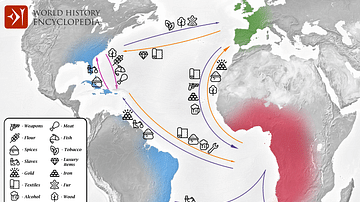
Transatlantic Triangular Trade Map
Map showing the flow of goods and enslaved people across the Atlantic between Europe, Africa and America in the transatlantic triangular trade which the European colonial powers operated from the 16th to the 19th centuries CE. This triangular...