
Search
Search Results

Image
The African Slave Trade, c. 1750
By 1750, Africa had emerged as the center of three major slave-trading systems: the transatlantic, trans-Saharan, and Indian Ocean trades. These interconnected networks linked African societies to European, Middle Eastern, and Asian markets...
Article
Indian Ocean Trade before the European Conquest
Finding a maritime route to the East and gaining access to the lucrative spice trade stood at the root of the European Age of Exploration. However, when Vasco da Gama rounded the Cape of Good Hope and reached the Indian Ocean in 1493, he...

Video
Sahara Desert Documentary HD - Africa's trade routes with Caravans of Gold
We always have to keep in mind that a Documentary, after all, can tell lies and it can tell lies because it lays claim to a form of veracity which fiction doesn't. Some of the documentaries are made just to discredit some particular person...
Image
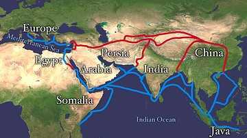
Map of the Silk Road Routes
This map indicates trading routes used around the 1st century CE centred on the Silk Road. The routes remain largely valid for the period 500 BCE to 500 CE.
Article
Trade in Ancient Celtic Europe
Trade in raw materials and manufactured goods in ancient Celtic Europe was vibrant and far-reaching, particularly regarding the centre of the continent where there was a hub of well-established trade routes. As the Celts' territory expanded...
Article
Carthaginian Trade
The Carthaginians, like their Phoenician forefathers, were highly successful traders who sailed the Mediterranean with their goods, and such was their success that Carthage became the richest city in the ancient world. Metals, foodstuffs...
Definition
Kingdom of Saba
Saba (also given as Sheba) was a kingdom in southern Arabia (region of modern-day Yemen) which flourished between the 8th century BCE and 275 CE when it was conquered by the neighboring Himyarites. Although these are the most commonly accepted...

Worksheet/Activity
Trade in the Roman Empire - Web Quest & Map Skills
This activity has been designed to fit a 20-30-minute slot for your class and is suitable for both online and classroom teaching. Students have to do a web quest in order to complete a map. It is part of our Roman Economy and Trade pack...
Image
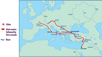
Map of the First Crusade Routes
"This map shows the main routes taken by those who joined the First Crusade. The appeal was made by Pope Urban II in November 1095 CE but crusaders did not set out until the following summer. One route went through Hungary crossing the Byzantine...

Article
Trade in Medieval Europe
Trade and commerce in the medieval world developed to such an extent that even relatively small communities had access to weekly markets and, perhaps a day's travel away, larger but less frequent fairs, where the full range of consumer goods...