
Search
Search Results
Image
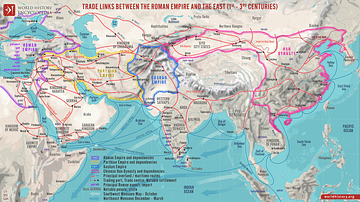
Trade Links between the Roman Empire and the East (1st - 3rd centuries)
A map illustrating the ever-growing and ever-changing trade network of maritime and overland routes connecting China, India, and the Far East with the Middle East and Europe. Even though the term "Silk Road" was not defined until the late...

Video
The Silk Road and Ancient Trade: Crash Course World History #9
The Silk Road and Ancient Trade: In which John Green teaches you about the so-called Silk Road, a network of trade routes where goods such as ivory, silver, iron, wine, and yes, silk were exchanged across the ancient world, from China to...
Definition
Kingdom of Axum
The African kingdom of Axum (also Aksum) was located on the northern edge of the highland zone of the Red Sea coast, just above the horn of Africa. It was founded in the 1st century CE, flourished from the 3rd to 6th century CE, and then...
Image
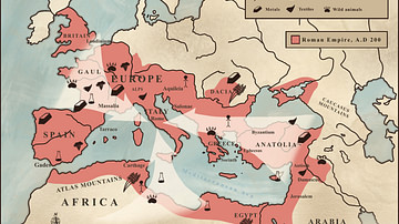
Trade in the Roman Empire Map (c. 200 CE)
This map shows the major sources of trade goods in the Roman Empire, circa 200 CE. The map shows the sources of the following trade goods: grain, olive oil, slaves, wine, metals, textiles and wild animals.
Image
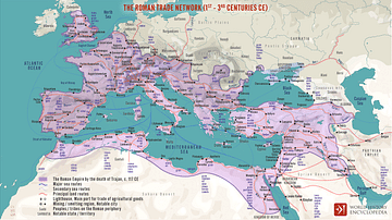
The Roman Trade Network (1st - 3rd centuries CE)
A map illustrating the principal trade routes of overseas and transregional exchange of goods across the Roman Empire between the first and third centuries. The depiction is schematic not only for the completeness of adequate historical knowledge...
Image
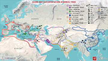
Second-Wave Civilization Natural Resources and Trade
A map illustrating the rise and spread of the Second Wave Civilizations between c. 500 BCE and 200 CE (including the Persians, the Greeks, the Romans, the Chinese, and India) with the flows of trade in major goods and resources.

Image
Western Sahara, Catalan Atlas
A map of West Africa from the 1375 CE Catalan Atlas. The map shows the trans-Saharan caravan trade routes between North Africa and the Niger River. (Sheet 6, National Library of France, Paris)
Image
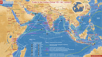
Trade in the Indian Ocean 15th-16th century
This map illustrates the Indian Ocean trade (15th–16th centuries), a vast maritime network linking East Africa, the Middle East, South Asia, and Southeast Asia, facilitating the exchange of spices, textiles, metals, timber, and luxury goods...
Image
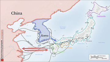
Map of Medieval Japanese Trade & Wako Pirates
Map depicting Medieval Japan and its trade relations with its neighbours, China and Korea. The map shows the major trade goods exchanged between Japan, China, and Korea. Black lines show the approximate routes taken by the Wako Pirates. Each...

Video
Roman Trade with Africa DOCUMENTARY
We are continuing our new animated historical documentary series on the Roman trade and economy with a video on the trade with Africa. Previously we have covered the Roman trade with India https://www.youtube.com/watch?v=eDTaOOVbxLs and the...