
Illustration


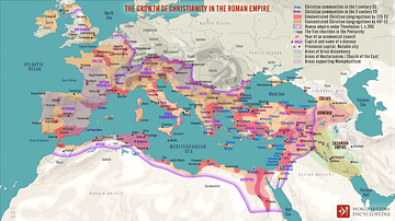
Map showing the spread of Christianity, showing both strongly Christianized areas before 325 CE and generally Christianized areas until 600 CE. The map also shows major Christian centers and the cities in which Christian councils were held.
Related Images
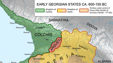
Map of Ancient Georgian States (600-150 BCE)
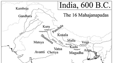
Map of India, 600 BCE
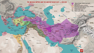
The Median Empire and the Ancient Near East, c. 600 BCE
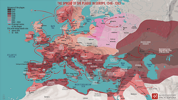
The Spread of the Plague in Europe, 1346 - 1353

The Spread of Islam in Africa
The Growth of Christianity in the Roman Empire
References
- Kinder, H., Hilgemann, W. dtv-Atlas Weltgeschichte. Deutscher Taschenbuch Verlag, 1999, 106.
Cite This Work
APA Style
Mykytiuk, K. (2020, January 16). Spread of Christianity Map (up to 600 CE). World History Encyclopedia. Retrieved from https://www.worldhistory.org/image/11713/spread-of-christianity-map-up-to-600-ce/
Chicago Style
Mykytiuk, Karyna. "Spread of Christianity Map (up to 600 CE)." World History Encyclopedia. Last modified January 16, 2020. https://www.worldhistory.org/image/11713/spread-of-christianity-map-up-to-600-ce/.
MLA Style
Mykytiuk, Karyna. "Spread of Christianity Map (up to 600 CE)." World History Encyclopedia. World History Encyclopedia, 16 Jan 2020. Web. 14 Apr 2025.