
Illustration


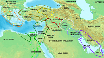
Map of Mesopotamia and the Ancient Near East c. 1300 BCE, showing the period of Great Powers, with the six large kingdoms and empires (the Hittites, the Mycenaean Civilization, Assyria, Babylonia, Elam and the New Kingdom of Egypt) co-existing in relative stability. This is the period of diplomacy with has produced the Amarna Letters and the Treaty of Kadesh, the first recorded peace treaty in history.
About the Author

Related Images
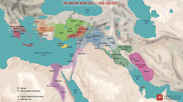
The Ancient Near East c. 1500-1300 BCE
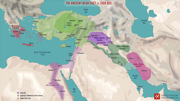
The Ancient Near East, c. 1300 BCE
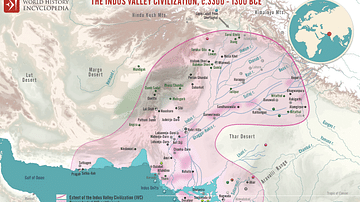
Map of the Indus Valley Civilization, c.3300 - 1300 BCE
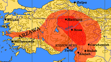
Hittite Empire c. 1300 BCE
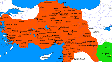
Map of the Hittite Empire (c. 1300 BC)
Map of the ancient Near East during the Amarna Period
References
World History Encyclopedia is an Amazon Associate and earns a commission on qualifying book purchases.Cite This Work
APA Style
Crabben, J. v. d. (2020, February 01). Map of Mesopotamia and the Ancient Near East, c. 1300 BCE. World History Encyclopedia. Retrieved from https://www.worldhistory.org/image/11823/map-of-mesopotamia-and-the-ancient-near-east-c-130/
Chicago Style
Crabben, Jan van der. "Map of Mesopotamia and the Ancient Near East, c. 1300 BCE." World History Encyclopedia. Last modified February 01, 2020. https://www.worldhistory.org/image/11823/map-of-mesopotamia-and-the-ancient-near-east-c-130/.
MLA Style
Crabben, Jan van der. "Map of Mesopotamia and the Ancient Near East, c. 1300 BCE." World History Encyclopedia. World History Encyclopedia, 01 Feb 2020. Web. 13 Apr 2025.