Illustration
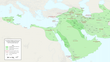
The extent of the Abbasid empire at its greatest extent has been shaded with green. The whole of the Arabian Peninsula, Persia, Iraq, Syria, parts of Asia Minor, Egypt, the North African coast excluding Morocco (Maghreb), Crete and the western half of Sicily were controlled by the Abbasid Empire at its height c. 850 CE.
Cite This Work
APA Style
Gabagool. (2020, March 18). Map of the Abbasid Empire. World History Encyclopedia. Retrieved from https://www.worldhistory.org/image/12000/map-of-the-abbasid-empire/
Chicago Style
Gabagool. "Map of the Abbasid Empire." World History Encyclopedia. Last modified March 18, 2020. https://www.worldhistory.org/image/12000/map-of-the-abbasid-empire/.
MLA Style
Gabagool. "Map of the Abbasid Empire." World History Encyclopedia. World History Encyclopedia, 18 Mar 2020. Web. 16 Apr 2025.


