
Illustration


A 1665 map drawn by Johannes Vingboons of the island of São Tomé in the Gulf of Guinea in West Africa. The island was a Portuguese colony from c. 1486 to 1975. (National Archives of the Netherlands)
License & Copyright
.jpg) Based on Wikipedia content that has been reviewed, edited, and republished.
Original image by Johannes Vingboons. Uploaded by Mark Cartwright, published on 27 May 2021. The copyright holder has published this content under the following license: Public Domain. This item is in the public domain, and can be used, copied, and modified without any restrictions. Please note that content linked from this page may have different licensing terms.
Based on Wikipedia content that has been reviewed, edited, and republished.
Original image by Johannes Vingboons. Uploaded by Mark Cartwright, published on 27 May 2021. The copyright holder has published this content under the following license: Public Domain. This item is in the public domain, and can be used, copied, and modified without any restrictions. Please note that content linked from this page may have different licensing terms.
Related Images
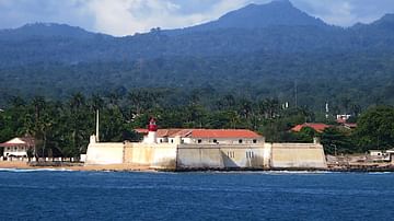
São Sebastiao Fort, São Tomé
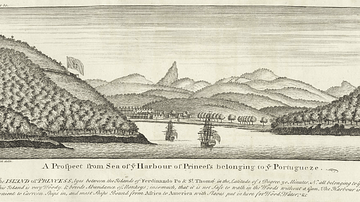
A View of the Harbour of Principe

Transatlantic Triangular Trade Map

Polynesian Migration Map

Elam Map

Battle of Brandywine Map
Cite This Work
APA Style
Vingboons, J. (2021, May 27). Historical Map of São Tomé. World History Encyclopedia. Retrieved from https://www.worldhistory.org/image/14115/historical-map-of-sao-tome/
Chicago Style
Vingboons, Johannes. "Historical Map of São Tomé." World History Encyclopedia. Last modified May 27, 2021. https://www.worldhistory.org/image/14115/historical-map-of-sao-tome/.
MLA Style
Vingboons, Johannes. "Historical Map of São Tomé." World History Encyclopedia. World History Encyclopedia, 27 May 2021, https://www.worldhistory.org/image/14115/historical-map-of-sao-tome/. Web. 06 May 2025.