
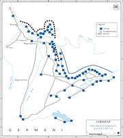
Illustration


Map showing the sights along the German Limes Road (German: Deutsche Limes-Straße) in Bavaria in Germany.
The Upper German-Raetian Limes forms the frontier of the Roman Empire between the rivers Rhine and Danube, and stretches 550 kilometres (342 miles). The frontier was in use from the beginning of 1st century CE to the second half of the 3rd century CE. The Upper German-Raetian Limes is part of the transnational UNESCO World Heritage Site "Frontiers of the Roman Empire" together with Hadrian's Wall and the Antonine Wall.
Image courtesy of Verein Deutsche Limes-Straße (German Limes Road Association).
About the Author

Related Images
The Limes in Germany

Allied Strategic Bombing of Germany, 1940 - 1945

The Rise of Nazi Germany, 1919 - 1939

Transatlantic Triangular Trade Map

Polynesian Migration Map
Elam Map
Cite This Work
APA Style
Raddato, C. (2021, August 24). Map of the Limes in Bavaria, Germany. World History Encyclopedia. Retrieved from https://www.worldhistory.org/image/14517/map-of-the-limes-in-bavaria-germany/
Chicago Style
Raddato, Carole. "Map of the Limes in Bavaria, Germany." World History Encyclopedia. Last modified August 24, 2021. https://www.worldhistory.org/image/14517/map-of-the-limes-in-bavaria-germany/.
MLA Style
Raddato, Carole. "Map of the Limes in Bavaria, Germany." World History Encyclopedia. World History Encyclopedia, 24 Aug 2021. Web. 13 Apr 2025.