
Illustration


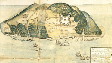
This map illustrates the maritime routes of Spain’s Treasure Fleets and the network of Caribbean ports and pirate havens around 1670. It captures the tension between imperial commerce and maritime raiding, showing both the logistical arteries of the Spanish Empire and the hotspots of buccaneer activity that flourished in its shadow.
The map traces the paths of the New Spain and Terra Firma Fleets, which transported gold, silver, and goods from the Americas to Europe. These convoys followed carefully guarded routes connecting the Spanish Main—the mainland colonies along the Caribbean coast—and the islands of the Spanish West Indies. Alongside these official trade lines, the map marks key pirate and buccaneer strongholds such as Tortuga, Port Royal, and Providence Island, where privateers and freebooters preyed on treasure ships. By the late 17th century, this region had become a volatile maritime frontier, where imperial ambition met seaborne rebellion, and wealth flowed in both sanctioned and stolen forms.
About the Author

Related Images
17th Century Tortuga
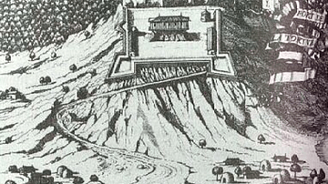
Vasseur's Fortress, Tortuga

A Buccaneer by Howard Pyle

Spanish Main & West Indies c.1720 - Spain, France, England, and the Dutch in a Struggle Over Trade, Treasure, and Empire

Abbey of Port-Royal-des-Champs

Destruction of the French Fleet at Toulon
Cite This Work
APA Style
Netchev, S. (2021, September 01). The Spanish Main and Caribbean Pirate Havens c. 1670. World History Encyclopedia. Retrieved from https://www.worldhistory.org/image/14550/the-spanish-main-and-caribbean-pirate-havens--c-16/
Chicago Style
Netchev, Simeon. "The Spanish Main and Caribbean Pirate Havens c. 1670." World History Encyclopedia. Last modified September 01, 2021. https://www.worldhistory.org/image/14550/the-spanish-main-and-caribbean-pirate-havens--c-16/.
MLA Style
Netchev, Simeon. "The Spanish Main and Caribbean Pirate Havens c. 1670." World History Encyclopedia. World History Encyclopedia, 01 Sep 2021, https://www.worldhistory.org/image/14550/the-spanish-main-and-caribbean-pirate-havens--c-16/. Web. 08 May 2025.