
Illustration


A map illustrating Christopher Columbus’s image of the world before his first voyage in 1492. It was based on a map by the Italian scholar Paolo dal Pozzo Toscanelli, which depicted the Earth as about 25% smaller than it actually is, exaggerated the reach of Asia to the east, and ignored the (correct) measurements of Eratosthenes from some 1700 years earlier. Columbus compounded these errors with his own wishful thinking and faulty mathematical assumptions. By his estimate, Asia (specifically, Japan, or Cipangu) lay only 2,500 miles (about 4,000 kilometers) west of Spain, an achievable distance for the ships of the time - he was mistaken by roughly 8,000 miles (around 13,000 kilometers).
About the Author

Related Images
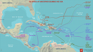
The Voyages of Christopher Columbus 1492-1504

Spanish Colonial Empire in the Age of Exploration
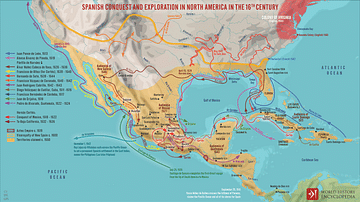
Spanish Conquest & Exploration in North America in the 16th century
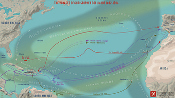
The Four Voyages of Christopher Columbus

Spanish Conquest & Exploration in South America in the 16th Century

Portuguese Colonial Empire in the Age of Exploration
Cite This Work
APA Style
Netchev, S. (2021, October 01). The World According to Columbus c. 1490. World History Encyclopedia. Retrieved from https://www.worldhistory.org/image/14664/the-world-according-to-columbus-c-1490/
Chicago Style
Netchev, Simeon. "The World According to Columbus c. 1490." World History Encyclopedia. Last modified October 01, 2021. https://www.worldhistory.org/image/14664/the-world-according-to-columbus-c-1490/.
MLA Style
Netchev, Simeon. "The World According to Columbus c. 1490." World History Encyclopedia. World History Encyclopedia, 01 Oct 2021, https://www.worldhistory.org/image/14664/the-world-according-to-columbus-c-1490/. Web. 17 Apr 2025.