
Illustration


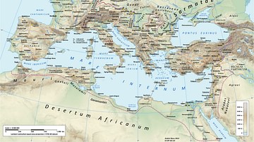
A map illustrating the principal trade routes of overseas and transregional exchange of goods across the Roman Empire between the first and third centuries. The depiction is schematic not only for the completeness of adequate historical knowledge of the exact ancient shipping channels but also for the alternating winds direction in the Mediterranean, which would make the outward and return paths different. The overland routes would have followed multitudes of roads and navigable waterways, which varied in diversity and complexity from province to province.
About the Author

Related Images

Diaspora Synagogues (1st - 2nd centuries CE)
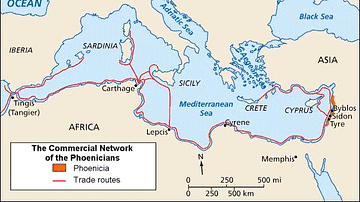
Phoenician Trade Network
Roman Road Network
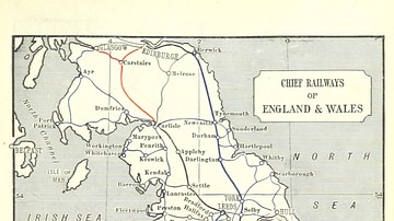
England & Wales Railway Network, 1898
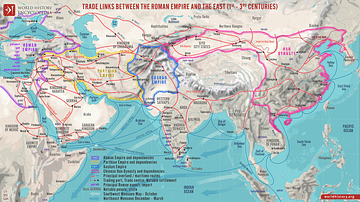
Trade Links between the Roman Empire and the East (1st - 3rd centuries)
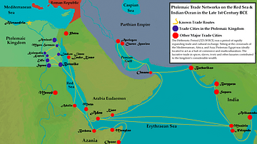
Ptolemaic Trade Networks in the Late 1st Century BCE
Cite This Work
APA Style
Netchev, S. (2022, April 07). The Roman Trade Network (1st - 3rd centuries CE). World History Encyclopedia. Retrieved from https://www.worldhistory.org/image/15641/the-roman-trade-network-1st---3rd-centuries-ce/
Chicago Style
Netchev, Simeon. "The Roman Trade Network (1st - 3rd centuries CE)." World History Encyclopedia. Last modified April 07, 2022. https://www.worldhistory.org/image/15641/the-roman-trade-network-1st---3rd-centuries-ce/.
MLA Style
Netchev, Simeon. "The Roman Trade Network (1st - 3rd centuries CE)." World History Encyclopedia. World History Encyclopedia, 07 Apr 2022, https://www.worldhistory.org/image/15641/the-roman-trade-network-1st---3rd-centuries-ce/. Web. 07 May 2025.