Illustration
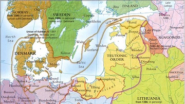
A map illustrating the expanse and complexity of the northern Europen trade network of commerce and the powerful association of cities and merchant guilds known as the Hanseatic League (from Old High German - Hanse for “guild,” or “association,” most probably based on a Gothic word for “company, troop, a gang of men”). At its height, the League numbered more than 200 cities across Northern Europe and maintained a trade monopoly along the coasts of the Baltic and the North Seas, from present-day Russia in the east to England and Scotland in the west.
About the Author
Cite This Work
APA Style
Netchev, S. (2022, September 14). The Hanseatic League - Trade in the North and Baltic Seas c. 1400. World History Encyclopedia. Retrieved from https://www.worldhistory.org/image/16368/the-hanseatic-league---trade-in-the-north-and-balt/
Chicago Style
Netchev, Simeon. "The Hanseatic League - Trade in the North and Baltic Seas c. 1400." World History Encyclopedia. Last modified September 14, 2022. https://www.worldhistory.org/image/16368/the-hanseatic-league---trade-in-the-north-and-balt/.
MLA Style
Netchev, Simeon. "The Hanseatic League - Trade in the North and Baltic Seas c. 1400." World History Encyclopedia. World History Encyclopedia, 14 Sep 2022. Web. 27 Mar 2025.


