
Illustration


This map illustrates the route and story of the Kon-Tiki Expedition (1947), a groundbreaking voyage led by Thor Heyerdahl (1914-2002), in which a crew of six sailed a balsa-wood raft from Callao, Peru, to Raroia Atoll in the Tuamotu Islands of Polynesia.
Covering 8,000 km (5,000 miles) in 101 days, the journey aimed to test Heyerdahl’s theory that pre-Columbian South Americans could have reached Polynesia using ocean currents. The raft, built using only traditional materials and techniques, relied on wind, currents, and four centerboards for stability. Despite skepticism of its success and modern scientific conensus that Heyerdahl was wrong in his theory that Polynesia was first settled by peoples coming from the east, the expedition successfully demonstrated that such a journey was possible, illustrating through experimental archaeology the potential of intercontinental travel in the ancient world.
About the Author

Related Images

Thor Heyerdahl, 1951

Chart of the Malay Archipelago and the Dutch Discoveries in Australia
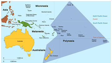
Map of Polynesia
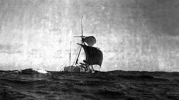
The Kon-Tiki Raft at Sea
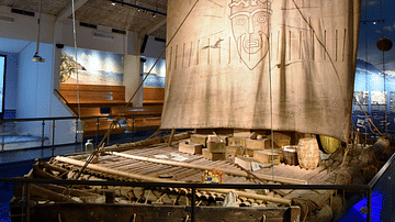
Front View of the Kon-Tiki Expedition Raft
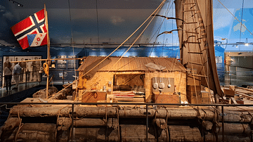
Side View of the Kon-Tiki Expedition Raft
Cite This Work
APA Style
Netchev, S. (2025, February 26). Thor Heyerdahl’s Kon-Tiki Expedition, 1947. World History Encyclopedia. Retrieved from https://www.worldhistory.org/image/20099/thor-heyerdahls-kon-tiki-expedition-1947/
Chicago Style
Netchev, Simeon. "Thor Heyerdahl’s Kon-Tiki Expedition, 1947." World History Encyclopedia. Last modified February 26, 2025. https://www.worldhistory.org/image/20099/thor-heyerdahls-kon-tiki-expedition-1947/.
MLA Style
Netchev, Simeon. "Thor Heyerdahl’s Kon-Tiki Expedition, 1947." World History Encyclopedia. World History Encyclopedia, 26 Feb 2025. Web. 16 Apr 2025.