
Illustration


This map illustrates the unfolding of Operation Barbarossa, the code name for Nazi Germany's invasion of the Soviet Union, launched on June 22, 1941 during the Second World War (1939-45). It was the largest military operation in history, involving over three million Axis troops and aiming to quickly defeat the Soviet Union through a three-pronged attack toward Leningrad in the north, Moscow in the center, and Ukraine in the south.
The campaign initially saw rapid German advances, with major Soviet defeats at the battle of Białystok-Minsk, the battle of Smolensk in 1941, and the battle of Kiev in 1941, leading to the capture of millions of Soviet soldiers. However, logistical challenges, stiff Soviet resistance, and the onset of winter stalled the offensive, culminating in the failure to capture Moscow by December 1941. The operation marked a turning point in WWII, as the prolonged German-Soviet war ultimately led to the destruction of the Third Reich.
About the Author

Related Images
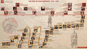
The Rise of Nazi Germany, 1919 - 1939
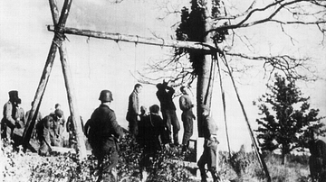
Hanged Soviet Civilians, Operation Barbarossa

Map of the Third Intermediate Period
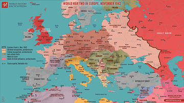
World War Two in Europe, November 1942
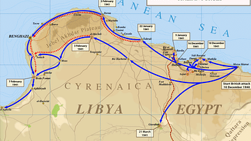
Map of Operation Compass
Europe After World War II (1945 to c. 1989)
Cite This Work
APA Style
Netchev, S. (2025, March 14). Map of Operation Barbarossa. World History Encyclopedia. Retrieved from https://www.worldhistory.org/image/20201/map-of-operation-barbarossa/
Chicago Style
Netchev, Simeon. "Map of Operation Barbarossa." World History Encyclopedia. Last modified March 14, 2025. https://www.worldhistory.org/image/20201/map-of-operation-barbarossa/.
MLA Style
Netchev, Simeon. "Map of Operation Barbarossa." World History Encyclopedia. World History Encyclopedia, 14 Mar 2025. Web. 14 Apr 2025.