
Illustration


A map showing the Siege of Leningrad (Saint Petersburg) during Operation Barbarossa, the invasion of the USSR launched by the leader of Nazi Germany Adolf Hitler (1889-1945) in the Second World War (1939-45). The siege, more accurately described as a blockade, lasted from 8 September 1941 to 27 January 1944. (Imperial War Museums)
License & Copyright
.svg) Based on Wikipedia content that has been reviewed, edited, and republished.
Original image by Willi P & WikiForMen. Uploaded by Mark Cartwright, published on 26 March 2025. The copyright holder has published this content under the following license: Creative Commons Attribution-ShareAlike. This license lets others remix, tweak, and build upon a work even for commercial reasons, as long as they credit the author and license their new creations under the identical terms. When republishing on the web a hyperlink back to the original content source URL must be included. Please note that content linked from this page may have different licensing terms.
Based on Wikipedia content that has been reviewed, edited, and republished.
Original image by Willi P & WikiForMen. Uploaded by Mark Cartwright, published on 26 March 2025. The copyright holder has published this content under the following license: Creative Commons Attribution-ShareAlike. This license lets others remix, tweak, and build upon a work even for commercial reasons, as long as they credit the author and license their new creations under the identical terms. When republishing on the web a hyperlink back to the original content source URL must be included. Please note that content linked from this page may have different licensing terms.
Related Images
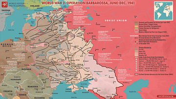
Map of Operation Barbarossa
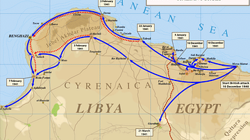
Map of Operation Compass

WWII North Africa Campaign, 1940-1943

Europe on the Eve of WWII, 1939
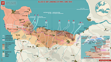
Allied D-Day Landings of WWII, June 1944

Africa in World War Two
Cite This Work
APA Style
WikiForMen, W. P. &. (2025, March 26). Map of the Siege of Leningrad. World History Encyclopedia. Retrieved from https://www.worldhistory.org/image/20269/map-of-the-siege-of-leningrad/
Chicago Style
WikiForMen, Willi P &. "Map of the Siege of Leningrad." World History Encyclopedia. Last modified March 26, 2025. https://www.worldhistory.org/image/20269/map-of-the-siege-of-leningrad/.
MLA Style
WikiForMen, Willi P &. "Map of the Siege of Leningrad." World History Encyclopedia. World History Encyclopedia, 26 Mar 2025, https://www.worldhistory.org/image/20269/map-of-the-siege-of-leningrad/. Web. 22 Apr 2025.