
Illustration


This map of the Near East in 1135 CE shows four Crusader States (marked with red crosses) in relation to other powerful kingdoms in the period between the first and second crusades.
License & Copyright
 Based on Wikipedia content that has been reviewed, edited, and republished.
Original image by MapMaster. Uploaded by Patrick Tinkham, published on 21 August 2018. The copyright holder has published this content under the following license: Creative Commons Attribution-ShareAlike. This license lets others remix, tweak, and build upon a work even for commercial reasons, as long as they credit the author and license their new creations under the identical terms. When republishing on the web a hyperlink back to the original content source URL must be included. Please note that content linked from this page may have different licensing terms.
Based on Wikipedia content that has been reviewed, edited, and republished.
Original image by MapMaster. Uploaded by Patrick Tinkham, published on 21 August 2018. The copyright holder has published this content under the following license: Creative Commons Attribution-ShareAlike. This license lets others remix, tweak, and build upon a work even for commercial reasons, as long as they credit the author and license their new creations under the identical terms. When republishing on the web a hyperlink back to the original content source URL must be included. Please note that content linked from this page may have different licensing terms.
Related Images
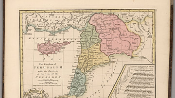
Kingdom of Jerusalem at the Time of the Crusades
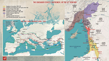
The First Three Crusades and the 12th-Century Latin East (Outremer)
Map of the Crusader States, 1229-1240 CE

The Seljuk Sultanate of Rum, c. 1200
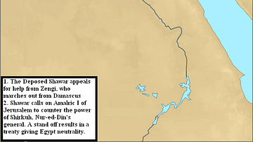
Second Crusader Invasion of Egypt, 1164 CE
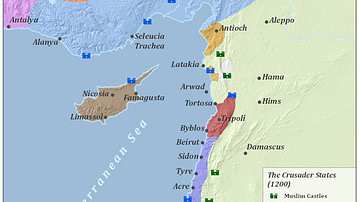
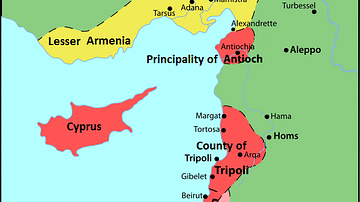
Crusader States 1200 CE
Cite This Work
APA Style
MapMaster. (2018, August 21). The Near East in 1135 CE. World History Encyclopedia. Retrieved from https://www.worldhistory.org/image/9048/the-near-east-in-1135-ce/
Chicago Style
MapMaster. "The Near East in 1135 CE." World History Encyclopedia. Last modified August 21, 2018. https://www.worldhistory.org/image/9048/the-near-east-in-1135-ce/.
MLA Style
MapMaster. "The Near East in 1135 CE." World History Encyclopedia. World History Encyclopedia, 21 Aug 2018, https://www.worldhistory.org/image/9048/the-near-east-in-1135-ce/. Web. 08 May 2025.