
Search
Remove Ads
Advertisement
Summary 
Loading AI-generated summary based on World History Encyclopedia articles ...
Search Results
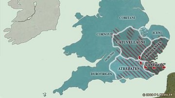
Image
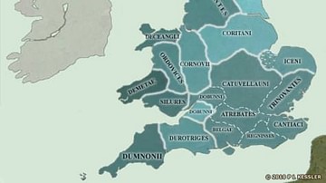
Map of the British Isles in AD 43
On the eve of the Roman Conquest, the south-east was dominated completely by the Catuvellauni. They, if any, could claim the legendary High Kingship of Britain. As well as having conquered the Cantiaci, the Trinovantes, and the Atrebates...
Image
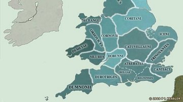
Map of the British Isles in AD 10
Rome maintained trading and political links of a sort with the Britons, and were able to observe the slow coalescence of the south-east towards the creation of a unified kingdom. The Catuvellauni, who had already proved themselves to be...
Definition
Roman Britain
Britain was a significant addition to the ever-expanding Roman Empire. For decades, Rome had been conquering the Mediterranean Sea – defeating Carthage in the Punic Wars, overwhelming Macedon and Greece, and finally marching into Syria and...
Image
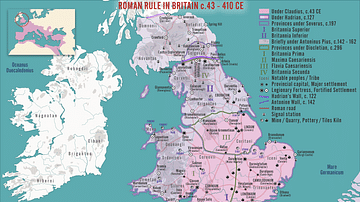
Map of Roman Britain, 150 AD
Map of Roman Britain ca. 150 AD, showing the main Roman roads, cities, and Brythonic tribes.
Image
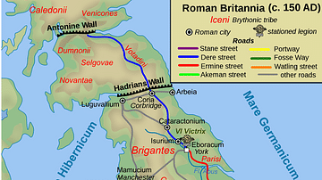
Map of the British Isles in 54 BC
When Julius Caesar landed on the Kent coast in 55 BC, he had a basic knowledge of what to expect of the south-eastern Britons from his dealings with their close relatives on the Continent. What he wasn't prepared for was the English Channel...