Search Images
Browse Content (p. 1742)

Image
The Abduction (Hercules and Alcestis)
An 1867 painting in oils, The Abduction by Paul Cézanne (1839-1906), the French post-impressionist artist. This painting is thought to depict Hercules rescuing Alcestis from the underworld (another theory is that this represents the abduction...

Image
Black-Figure Hercules & Nessos
Attic black-figure funerary amphora depicting Heracles wrestling down the Centaur Nessos, from a tomb in Athens, 620-610 BCE. (National Archaeological Museum of Athens)

Image
Bust of Hercules
Marble bust of Hercules, Roman copy after Greek original, 117-118 CE, made for Hadrian for his villa at Tivoli. (British Museum)

Image
Hercules
Statue of Hercules, Parc de Versailles, by Louis Leconte (19th century CE)

Image
Scene from the Shield of Hercules
Zeus separates Athena and Ares while Cycnus (far right) runs away from Hercules who approaches in his chariot (only the horses are visible, far left). Attic black-figured volute-krater, ca 540–510 BCE.

Image
Hercules Fighting Death to Save Alcestis
Hercules Fighting Death to Save Alcestis by Frederic, Lord Leighton, 1869-71 CE.

Image
Megara Statue
Statue of Megara in Bluherpark, Dresden, Germany.

Image
Nessus Abducting Deianira
Nessus Abducting Deianira by Bertel Thorvaldsen, 1814 CE. The centaur Nessus tries to abduct Deianira, Hercules' wife, only to be slain by Hercules' poison arrow.

Image
Hercules and the Nemean Lion
Heracles fighting the Nemean Lion. Silver missorium, 6th century CE (?) (Cabinet des Médailles, more formally known as Département des Monnaies, Médailles et Antiques de la Bibliothèque nationale de France, Paris, France.)

Image
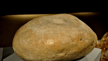
A door socket from Dur-Karikalzu
The cuneiform inscriptions on this door socket mention the name of the Kassite king Kurikalzu. Kassite era, 1595-1157 BCE. From Dur-Kurikalzu (modern Agarguf, southwest of Baghdad). (The Sulaimaniya Museum, Iraq). (A door socket is the stone...