
Search Images
Browse Content (p. 1768)
Image
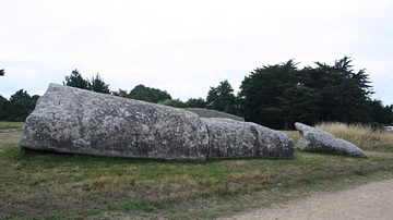
Grand-Menhir, Locmariaquer
Three of the remaining pieces of the Grand-Menhir at the Neolithic site of Locmariaquer in north-west France. The menhir once stood 20 metres high and weighed 280 tons. It toppled and broke into four pieces c. 4,000 BCE, a few hundred years...
Image
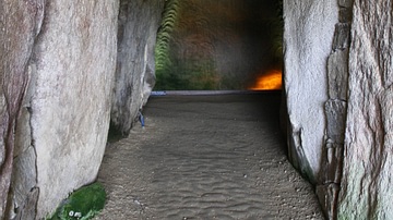
Neolithic Tumulus Interior, Locmariaquer
The interior chamber of the stone burial mound known as the Table-des-Marchands (Table of Merchants) at the Neolithic site of Locmariaquer in north-west France. The tomb was constructed in the 5th millennium BCE and is so called because of...
Image
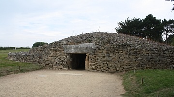
Table-des-Marchands Tumulus, Locmariaquer
The stone burial mound known as the Table-des-Marchands (Table of Merchants) at the Neolithic site of Locmariaquer in north-west France. The tomb was constructed in the 5th millennium BCE and is so called because of the large flat stone which...

Image
Millet
Millet was a cereal widely used in the ancient world.
Image
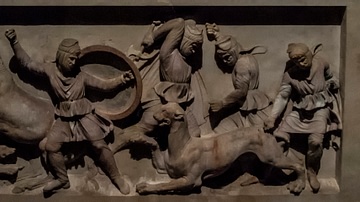
Alexander Sarcophagus
This is a side panel of the Alexander Sarcophagus, a stone sarcophagus adorned with bas-relief carvings of Alexander the Great from the 4th century BCE. Discovered in Sidon, Lebanon and residing in the Istanbul Archaeology Museum today.

Image
Cleobis & Biton
Two high archaic kouroi, inscribed as Cleobis and Biton. c.580 BCE. These kouroi are over-life-size, standing at 6.5m tall, and are currently housed at the Delphi Museum. The sculptor was Polymides of Argos.
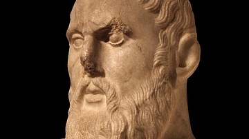
Image
Zeno of Citium Bust
A bust of Zeno of Citium. Found in 1823 CE near the Jardin des Plantes and the ampitheatre. Esperandieu, 1768 CE.

Image
Map of the Hittite Empire
A map showing the Hittite Empire in c. 1350-1300 BCE (dark green line) and at its maximum extent (light green area).
![Crates of Thebes [Painting]](https://www.worldhistory.org/img/c/p/360x202/2913.jpg?v=1765223765)
Image
Crates of Thebes [Painting]
A portrait of the Greek Cynic philosopher Crates of Thebes by an unknown painter from the circle of Domenico Feti.

Image
Spartan Woman Bronze Statue
A bronze statue, likely of a Spartan woman. c. 500 BCE. (British Museum, London)