
Search Images
Browse Content (p. 1775)
![Greek Trireme [Illustration]](https://www.worldhistory.org/img/c/p/360x202/154.jpg?v=1739953088)
Image
Greek Trireme [Illustration]
Model of a Greek Trireme.
Displayed at Deutsches Museum, Munich, Germany.

Image
Map of Lydia
Map of Lydia in the middle of the 6th century BCE. The red line shows an alternative interpretation of Lydia's ancient borders.
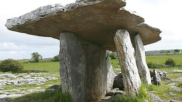
Image
Poulnabrone Dolmen
Poulnabrone Dolmen, County Clare, Ireland. Poulnabrone Dolmen (Poll na mBrón in Irish meaning "hole of sorrows") is a portal tomb in the Burren, County Clare, Ireland, dating back to the Neolithic period, probably between 4200 BC to 2900...
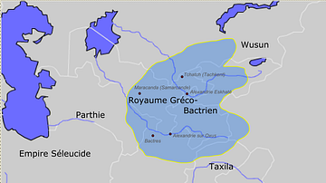
Image
Greco-Bactrian kingdom circa 230-200 BC
Approximate borders of the Greco-Bactrian kingdom under Euthydemos' reign (c.230BC - c.200BC). The kingdom included Bactria, Oxeiana, Sogdiana and Ferghana.

Image
Ur-Nammu
Ur-Nammu (seated) bestows governorship on Ḫašḫamer, patesi (high priest) of Iškun-Sin (cylinder seal impression, c. 2100 BCE). Greenstone seal(clay impression of the cylinder seal) of Hashhamer, Governor of Ishkun-Sin. Third Dynasty...
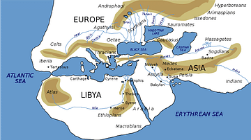
Image
World Map of Herodotus
Possibly what the Greek historian Herodotus believed the world looked like (5th century BCE) based on his writings.
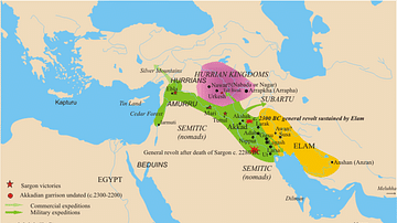
Image
Map of the Akkadian Empire
The empire of Sargon, late 24th century BCE.
Image
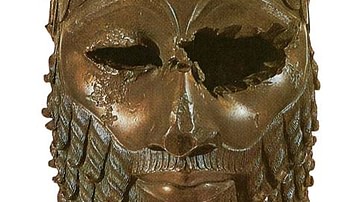
Akkadian Ruler
Bronze head of an Akkadian ruler, probably Sargon the Great, c. 23rd - 22nd century BCE.
Image
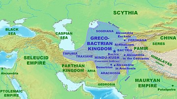
Map of the Greco-Bactrian Kingdom
Approximate maximum extent of the Greco-Bactrian kingdom circa 180 BCE, including the regions of Tapuria and Traxiane to the West, Sogdiana and Ferghana to the north, Bactria and Arachosia to the south.

Image
Satyrs Making Wine
Satyrs making wine, dionysian bas-relief from altar of unknown date, National Archaeological Museum of Athens.