Search Images
Browse Content (p. 187)

Image
German Troops Enter the Sudetenland
A photograph showing Sudeten Germans welcoming German troops during the first stage of Adolf Hitler's occupation of Czechoslovakia in October 1938. The Sudetenland was occupied as it contained some three million German speakers. (Imperial...

Image
Chamberlain & Hitler at Berchtesgaden
A photograph showing the British Prime Minister Neville Chamberlain (1869-1940) and Adolf Hitler (1889-1945), the leader of Nazi Germany at Berchtesgaden, Bavaria on 15 September 1938 during the Sudentenland crisis which ended with Hitler's...

Image
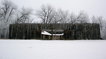
Reconstruction of Fort Mandan
A reconstruction of Fort Mandan, where the Lewis and Clark Expedition spent the winter of 1804-05 near Washburn, North Dakota.
Photo by Wikipedia user Gooseterrain 2, 14 December 2012.

Image
Sacagawea with Lewis and Clark
Sacagawea guides Lewis and Clark at the Three Forks of the Missouri River, 1805. Detail from a mural by Edgar Samuel Paxson, in the lobby of the Montana House of Representatives.
Photograph taken at the Montana State Capitol, 2012.

Image
Lewis and Clark Meet the Salish Indians, September 1805
The Lewis and Clark Expedition meets the Salish Indians after crossing the Bitterroot Mountains in September 1805. Painting by Charles Marion Russell, 1912.
Montana Historical Society.

Image
Lewis and Clark Reach the Shoshone Camp
The Lewis and Clark Expedition reaches the camp of the Shoshones, August 1805. Oil on canvas painting by Charles Marion Russell, 1918.
Gilcrease Museum.

Image
Meriwether Lewis
Meriwether Lewis, portrait by Charles Willson Peale, c. 1807.

Image
William Clark
William Clark, portrait by Charles Willson Peale, c. 1810.

Image
Pretty Nose, Arapaho Warrior who Fought at the Battle of the Little Bighorn
Pretty Nose (l. c. 1851-1952), Arapaho (possibly Arapaho-Cheyenne) warrior who fought at the Battle of the Little Bighorn in June 1876. She lived to be 101 years old. Photo taken at Fort Keogh, Montana, 1879.

Image
Bloody Knife, Arikara-Sioux Scout for US Army
Bloody Knife (l. c. 1840-1876), Arkiara-Sioux scout for the US Army, c. 1873. He was George Armstrong Custer's favorite scout, confidante, and friend. Prior to the Battle of the Little Bighorn, Bloody Knife tried to warn Custer that there...