Search Images
Browse Content (p. 516)

Image
Ratification of the Canons of the Council of Trent
Pope Pius IV promulgates the bull Benedictus Deus, ratifying the Canons of the Council of Trent in 1564. Fresco by Pasquale Cati, 1588.
Altemps Chapel, Santa Maria in Trastevere, Rome.

Image
Map of Spain and the Spanish Indies
This map illustrates the dramatic rise and gradual decline of Spain as a global imperial power between the late 15th and late 17th centuries. Emerging from a union of northern Iberian kingdoms, Spain reached its zenith under Habsburg rule...

Image
Massacre at Cumaná
A 17th-century illustration showing the massacre of the Spanish community at Cumaná on Hispaniola in 1515. The community was an attempt at a more peaceful rule over indigenous peoples.

Image
Bartolomé de Las Casas by Parra
A 19th-century painting by Felix Parra (1845-1919) of the Dominican friar Bartolomé de Las Casas (1484-1566) who sought to end the abuses of indigenous peoples going on in the New World.

Image
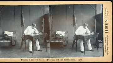
Alfred Dreyfus on Devil's Island
Alfred Dreyfus on Devil's Island in 1898, stereoscopy by F. Hamel, Altona-Hamburg.

Image
Law of Separation of Churches and the State
Law of Separation of Churches and the State, 1905.
National Archives of France.

Image
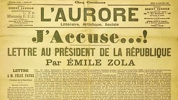
J'Accuse
J'Accuse, open letter about the Dreyfus Affair by Émile Zola, published in L'Aurore, 13 January 1898.

Image
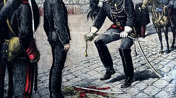
Alfred Dreyfus Stripped of Rank
Alfred Dreyfus stripped of his rank, illustration published in the Petit Journal, 13 January 1895.
National Library of France, Paris.

Image
Map of the Early Christian Pilgrimage (4th-5th Century)
The rise of Christian pilgrimage begins after the conversion of Emperor Constantine (reign 306–337 CE) and the legalization of Christianity in the Edict of Milan (313 CE). The word pilgrim comes from the Latin peregrinus meaning “stranger”...

Image
Fresco Depicting the Council of Trent
Council of Trent (1545-1563), fresco by Pasquale Cati, 1588.
Basilica of Santa Maria in Trastevere.